Proposed redistribution of New South Wales into electoral divisions
Updated: 14 October 2015
Chapter 2 Proposed redistribution and reasons for proposal
This chapter outlines the Committee’s proposed redistribution and the reasons for this proposal. Also included is the Committee’s approach to formulating the proposed boundaries and the names of electoral divisions.
The Committee’s proposed redistribution has three elements:
defining the boundaries of electoral divisions,
abolishing an existing electoral division, and
naming of electoral divisions.
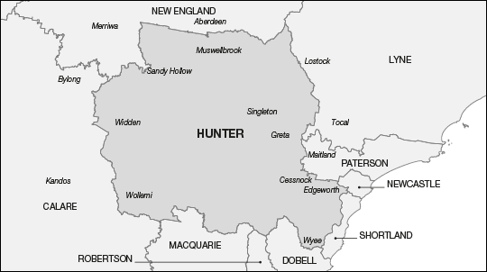
The Committee proposes abolishing the existing Division of Hunter.18 However, acknowledging that ‘Hunter’ is a Federation name, the Committee proposes to rename the proposed Division of Charlton as ‘Hunter’, thereby retaining a Federation name.
Further the Committee proposes to rename the existing Division of Throsby as ‘Whitlam’ in honour of the former Prime Minister, the Hon. Edward Gough Whitlam AC, QC.1920
Wherever possible the Committee used the opportunity to more clearly define electoral boundaries. In some cases no elector movement was involved.
Committee’s approach to formulating proposed electoral boundaries
The Committee’s general strategy for formulating proposed electoral boundaries was based on, and conforms to, the requirements of the Electoral Act.
The Committee acknowledged the importance of the principle of relative equality of the number of electors in electoral divisions and the flexibility provided by the numerical tolerances contained in the Electoral Act. The Committee considered that, where necessary, the use of these tolerances allowed it to construct electoral divisions which addressed all other criteria.
Within the limits imposed by the numerical criteria and the other considerations, the Committee acknowledged that it is also highly desirable that electoral boundaries be readily recognisable. Local government area (LGA) boundaries, locality boundaries, main roads, railways, waterways and other suitable linear features, guided the Committee, where appropriate.
The Committee noted that a range of methods could be applied to achieve a proposed redistribution outcome for New South Wales. Submissions addressing the state as a whole adopted varying approaches and proposed moving between, approximately, 12 and 25 per cent of electors into a different electoral division.
Submissions dealing with specific regions generally sought to improve electoral boundaries and to strengthen local communities of interest by bringing together neighbouring localities into a single electoral division and/or by suggesting LGA boundaries as divisional boundaries. In its deliberations the Committee noted that those submissions that proposed electoral boundaries for specific regions of the state would need to be considered in the broader context of their impact on the state as a whole.
As previously outlined, the Committee applied, to the extent possible, the following principles when considering the new electoral boundaries:
proposed electoral boundaries should not cross the major geographic features of the Great Dividing Range, the Hawkesbury River and Sydney Harbour,
communities of interest represented by LGAs and localities are kept together, particularly in rural areas,
strong and readily identifiable features such as major roads, railway lines and waterways are used to define electoral division boundaries, and
the maximum numbers of electors are retained in their current electoral division.
The Committee identified that the existing electoral divisions within the state fell into three categories:
those within 3.5 per cent of projected enrolment (19 inner and outer metropolitan electoral divisions, three provincial electoral divisions and one rural electoral division),
those above 3.5 per cent of projected enrolment (six inner and outer metropolitan electoral divisions), and
those below 3.5 per cent of projected enrolment (one outer metropolitan electoral division, five provincial electoral divisions and 13 rural electoral divisions).
The Committee recognised that the growth in projected enrolment in rural areas was lower than that in provincial and, in particular, metropolitan areas. The Committee considered this a continuation of a trend reported in the 2006 New South Wales Redistribution.21
In these circumstances, the Committee reasoned that a strategy of supplementation from those six metropolitan electoral divisions with projected enrolment above the permissible 3.5 per cent tolerance, combined with the required abolition of an electoral division, would bring all proposed electoral divisions within the numerical requirements of the Electoral Act.
Three suggestions specifically highlighted that rural New South Wales did not have the projected enrolment numbers to maintain their current number of electoral divisions, continuing that rural New South Wales also needed to gain approximately 40 000 or more electors from the Greater Sydney Region to allow those remaining rural electoral divisions to achieve the numerical tolerance.
Further, the Committee acknowledged that, for the supplementation strategy to be effective there would need to be changes to the majority of electoral divisions, despite 23 electoral divisions being within the 3.5 per cent tolerance of projected enrolment.
The location of those electoral divisions providing supplementation in and around central Sydney and outer metropolitan western Sydney results in the surrounding metropolitan and provincial electoral divisions moving north and east to accommodate the transfer of surplus projected enrolment from the Divisions of Wentworth, Sydney, Grayndler, Reid, Greenway and Chifley.
The relatively low growth in projected enrolment in rural electoral divisions requires a general eastward movement of these divisions and an increase in their geographical size.
The Committee recognised that, in implementing their supplementation strategy, many electoral divisions would undergo consequential changes to facilitate the transfer of surplus projected enrolment to those electoral divisions requiring supplementation.
The Committee also acknowledged that defining electoral boundaries must start in locations adjacent to the state’s boundaries or one of the other significant geographical features identified above. The location of the electoral division to be abolished would be determined by the application of this strategy.
In proposing its boundaries the Committee recognises it has proposed a number of changes to electoral boundaries that may be regarded as significant. Examples of these include:
the increased geographic size of the proposed Division of Parkes and consequential reduction in the geographic size of the proposed Division of Farrer,
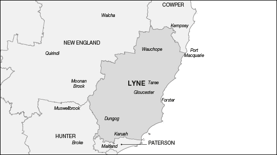
the relative increase in the geographic size of the proposed Division of Lyne and the consequential decrease in the proposed Division of Paterson,
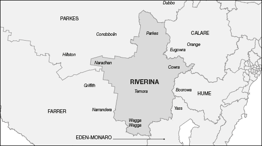
the reduction in geographic size of the proposed Divisions of Hume and Riverina contributing to a consequential increase in the geographic size of the proposed Division of Eden-Monaro, and
the inclusion of the major mid-north coast centres of Port Macquarie and Coffs Harbour in the same proposed electoral division.
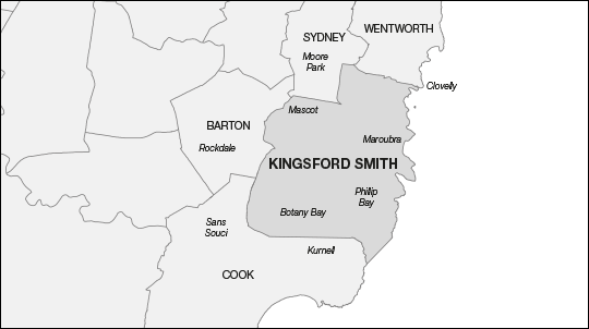
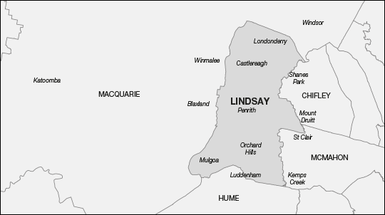
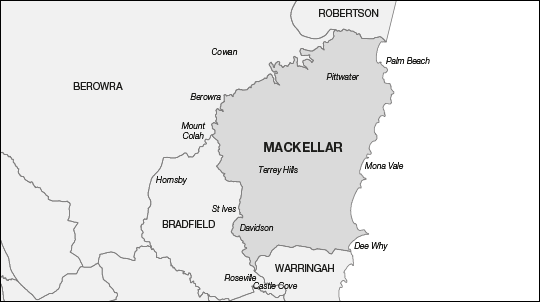
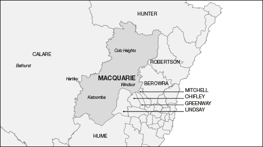
The supplementation strategy enabled the Committee to propose five electoral divisions with no elector movement. These are the Divisions of Bennelong, Kingsford Smith, Lindsay, Mackellar and Macquarie. The boundaries of the remaining electoral divisions were adjusted to meet the numerical requirements of the Electoral Act.
However the Committee recognised the opportunity to better align some existing electoral division boundaries and proposes to amend these boundaries where appropriate. This alignment of boundaries, in some cases, does not involve any elector movement, and instances where this occurred are detailed in the discussion of proposed electoral divisions for the electoral divisions involved.
Detailed descriptions of the Committee’s deliberations in determining its proposed electoral boundaries are contained in this chapter, under the section titled ‘Proposed redistribution of New South Wales – by electoral division’.
In formulating the redistribution proposal, the Committee noted the removal of an electoral division projected to contain some 100 000 electors would result in significant elector movement from the electoral division being abolished and will also require consequential boundary changes and elector movements across the state in order to maintain equality of elector numbers between electoral divisions. The Committee sought, to the extent possible, to minimise the movement of electors between electoral divisions. Table F outlines the extent of elector movements resulting from the proposed boundaries.
Table F: Summary of movement of electors between proposed electoral divisions
Number
Percentage
Electors remaining in their existing electoral division
3 919 001
80.58%
Electors transferred to another electoral division
944 592
19.42%
Total
4 863 593
100.00%
Committee’s approach to determining the electoral division proposed to be abolished
The Committee’s approach to determining which electoral division to propose for abolition was guided by the provisions of the Electoral Act; namely the numerical requirements and the obligations relating to community of interests, means of communication and travel, the physical features and area of the proposed electoral division and the boundaries of existing electoral divisions.
The Committee acknowledged that of the 23 suggestions received, 11 proposed one or more specific electoral divisions for abolition,22 with 13 different electoral divisions named. Eleven suggestions advocated that the electoral division to be abolished should be located in the coastal area from the Hawkesbury River to the Queensland border. Most suggestions nominated electoral divisions located in this region while other suggestions expanded their area of consideration to include those electoral divisions located on the western side of the Great Dividing Range.
In support of their suggestion to abolish an electoral division in that part of the state, several suggestions noted a significant shortfall of projected enrolment in that region. Other suggestions particularly noted that there are currently 12 electoral divisions in this area whereas projected enrolment figures provide for an entitlement of 11 electoral divisions only. Eleven of these 12 electoral divisions need to gain electors to meet the numerical requirements of the Electoral Act, with the Division of Robertson being the exception.
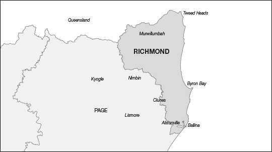
The Committee, noting that the capacity for building the electoral divisions between the Hawkesbury River and the Queensland border is limited by that border, the Great Dividing Range and the coast, determined that the Division of Richmond located in this north-eastern corner of the state must be the starting point. The Committee was conscious that, in redrawing boundaries for electoral divisions in this corridor between the mountains and the coast, each proposed electoral division would progressively move towards the Hunter Valley Region.
Similarly, in redrawing the boundaries for those electoral divisions located immediately north of the Hawkesbury River, the Committee accepted that the Division of Robertson must be the starting point and that these proposed electoral divisions would also move towards the Hunter Valley Region. Further, the Committee noted that this region provides the first opportunity to move westward without crossing the Great Dividing Range or a significant spur of the range. Part or all of the existing Divisions of Charlton, Hunter, Newcastle, Paterson and Shortland fall within the Hunter Valley Region.
The ‘push’ towards the Hunter Valley Region by the existing electoral divisions to its north and south result in the movement westward of these Hunter Valley Region electoral divisions. This movement results in the existing Division of Charlton retaining 57.60 per cent of itself and needing to gain electors to meet the numerical requirements of the Electoral Act which can only be obtained from the existing Division of Hunter. The Committee notes that, following the transfer of electors to the proposed Divisions of Charlton and Paterson, the existing Division of Hunter retains only 11.71 per cent of itself.
In these circumstances, the Committee unanimously proposes the abolition of the existing Division of Hunter.
Committee’s approach to naming electoral divisions
The naming of federal electoral divisions has been the subject of a number of recommendations from parliamentary committees. The ‘Guidelines for naming federal electoral divisions’ (the guidelines) were developed by the AEC from recommendations made by the Joint Standing Committee on Electoral Matters in 1995 in their Report on the Effectiveness and Appropriateness of the Redistribution Provisions of Parts III and IV of the Commonwealth Electoral Act 1918. The guidelines were offered to interested persons when this redistribution was advertised, and are publicly available on the AEC website (see Appendix H).
The Committee noted that, since Federation, all electoral divisions have moved from their original location and changed in size as New South Wales’ relative share of the six states population changed over time. Additionally, the Committee recognised that, of the original 26 Federation electoral divisions only three, the Divisions of Richmond, Wentworth and Eden-Monaro, have remained in the same relative position in the state.
Renaming of electoral divisions
The guidelines note that the names of electoral divisions should not be changed or transferred to new areas without very strong reasons. Any decision to alter the name of an electoral division is not taken lightly.
The Committee received a number of suggestions and comments on suggestions proposing that electoral divisions be renamed, as displayed in Table G.
While noting the contribution to Australian society of those individuals submitted for its consideration and the general relevance of all names submitted, the Committee considered it was first required to determine whether the name of current electoral divisions should be changed or retained.
Table G: Proposed new names for electoral divisions
received in public submissions
Existing name of electoral division
Proposed new name
Werriwaa
Whitlam – in honour of the former Prime Minister, the Hon. Edward Gough Whitlam, AC, QC (1916–2014) in recognition of his service to Australia
Fowler
Throsby
Hughes
McMahon
Macarthur
Bradman – in honour of Sir Donald Bradman, AC (1908–2001) in recognition of his service to Australian cricket
Riverina
Eden-Monaro
Snowy Mountains – to better reflect suggested changes to this electoral division
Cowper
Paterson – to retain the name of Andrew ‘Banjo’ Paterson (1864–1941), Australian author and poet
Cunningham
Hughes – to retain the name of the former Prime Minister the Rt Hon. William Morris Hughes, CH, KC (1862–1952)
Richmond
Bandler – in honour of Faith Bandler, AC (1918–2015), in recognition of her role as a leader of the 1967 referendum campaign in favour of two constitutional amendments relating to Indigenous Australians
a ‘Werriwa’ was first used as an electoral division name in 1901. ‘Hughes’ was first used as the name of an electoral division in 1955. ‘Fowler’ and ‘Throsby’ were first used as names for electoral divisions in 1984. ‘McMahon’ was first used as the name of an electoral division in 2009.
In deciding to abolish the existing Division of Hunter, the Committee observed that the name ‘Hunter’ was a Federation name: first used as the name of an electoral division in 1901. The guidelines note that every effort should be made to retain the names of original federation electoral divisions. The Committee therefore considered whether it would be appropriate to rename another electoral division. In doing so, the Committee noted that:
the proposed Division of Charlton consists of 53.13 per cent of electors from the existing Division of Charlton and 46.87 per cent from the existing Division of Hunter, and
‘Charlton’, was first used as the name of an electoral division in 1984.23
The Committee notes that the existing Division of Charlton provides more than 50 per cent of the proposed electoral division. However, the Committee also acknowledges that the socio-demographic nature of the proposed Division of Charlton has changed from an urban provincial electoral division to a largely rural electoral division.
The Committee therefore considers there are strong reasons to name the proposed electoral division ‘Hunter’ in continued recognition of John Hunter (1737–1821) who was the second Governor of New South Wales (1795–99).24 The Committee also considers that ‘Hunter’ is an appropriate name for an electoral division located in this geographic area. This part of New South Wales is synonymous with the name Hunter as evidenced by the names provided by various governments to locations, institutions and organisations in general including Hunter Region, Hunter River, Hunter Valley, John Hunter Hospital, Upper Hunter LGA, Upper Hunter State District and Hunter Valley Statistical Area 4.25 The Committee also notes that for many years prior to the 1984 federal redistribution the Division of Hunter included the western side of Lake Macquarie.
With respect to renaming the proposed Division of Charlton as ‘Hunter’, the Committee unanimously agreed to do so.
Table G displays the five existing electoral divisions which were suggested for renaming in honour of the former Prime Minister, the Hon. Edward Gough Whitlam, AC, QC (1916–2014).26 However, the Committee considers that it would not be appropriate to rename several of those electoral divisions nominated.
The Committee notes that of those electoral divisions suggested to be renamed ‘Whitlam’, two, the Divisions of Hughes and McMahon are named after former Prime Ministers. Further, the Division of Werriwa has an Aboriginal name and is also a Federation electoral division. The Committee accepts that, in accordance with the guidelines, it is not appropriate to rename these three electoral divisions.
Additionally, the Committee considers that it would not be appropriate to rename the Division of Fowler, acknowledging that this electoral division is one of only four electoral divisions in New South Wales named after women.
The Committee notes the reasons provided in the suggestions and comments on suggestions for renaming the Division of Werriwa as ‘Whitlam’ include:
the electoral division has moved from its original location around Lake George, and
the former Prime Minister was the Member for Werriwa.
However, the Committee observes that since Federation all electoral divisions have moved from their original location and changed in size as New South Wales’ relative share of the six states’ population changed over time. Additionally, the Committee identifies that of the original 26 Federation electoral divisions only three, the Divisions of Richmond, Wentworth and Eden-Monaro, remain in the same relative position in the state.
Consistent with the guideline that consideration should be given to naming electoral divisions after former Prime Ministers, the Committee considered other alternatives noting the suggestion and comment on suggestion to rename the Division of Throsby. The Committee accepted these submissions and therefore unanimously proposes renaming the Division of Throsby as ‘Whitlam’ in honour of the former Prime Minister, the Hon. Edward Gough Whitlam, AC, QC (1916–2014) in recognition of his service to Australia.
Proposed redistribution of New South Wales – by electoral division
In drawing the proposed electoral division boundaries the Committee was conscious of the numerical requirements of the Electoral Act, community of interest principles, the need for easily recognisable boundaries in the form of natural and man-made features having regard to the geography and transport infrastructure of the area and minimising the number of electors moved from their existing electoral division.
As the New South Wales state boundaries are immoveable, the Committee agreed that the redrawing of electoral division boundaries must commence in those electoral divisions located adjacent to the state’s boundaries and large geographic features such as the Great Dividing Range, Sydney Harbour and the Hawkesbury River.
The Committee recognised that any changes required to ensure the six electoral divisions between Sydney Harbour and the Hawkesbury River were within the numerical tolerance could be achieved from within those electoral divisions. Consequently, the redrawing of electoral boundaries commenced with the Divisions of Richmond and Wentworth.
The Committee has examined each proposed electoral division, giving due consideration to the requirements of the Electoral Act. For each of the proposed electoral divisions in New South Wales, Table H presents:
initial enrolment based on enrolment figures as at 1 December 2014,
percentage variation from the current enrolment quota,
projected enrolment as at 25 August 2019,
percentage variation from the projected enrolment quota, and
the approximate area of each proposed electoral division.
Table H: Summary of proposed electoral divisions
Proposed electoral division
Enrolment as at 1 December 2014
Projected enrolment as at 25 August 2019
Approximate area
Number
Percentage variation from the current enrolment quota
Number
Percentage variation from the projected enrolment quota
Banks
104 742
1.22%
112 771
2.02%
51 km2
Barton
99 015
- 4.32%
108 631
-1.73%
38 km2
Bennelong
102 693
- 0.76%
110 876
0.30%
60 km2
Berowra
103 320
-0.16%
110 861
0.29%
786 km2
Blaxland
100 061
-3.30%
109 746
-0.72%
63 km2
Bradfield
103 027
-0.44%
110 742
0.18%
101 km2
Calare
107 827
4.20%
111 814
1.15%
32 666 km2
Chifley
97 924
-5.37%
108 528
-1.82%
126 km2
Cook
101 317
-2.09%
109 035
-1.36%
94 km2
Cowper
112 408
8.63%
114 199
3.31%
7 296 km2
Cunningham
106 644
3.06%
110 111
-0.39%
519 km2
Dobell
104 955
1.42%
112 143
1.45%
787 km2
Eden-Monaro
103 542
0.06%
107 383
-2.86%
41 617 km2
Farrer
108 835
5.17%
112 771
2.02%
114 870 km2
Fowler
102 588
-0.86%
112 302
1.59%
56 km2
Gilmore
109 804
6.11%
111 230
0.62%
6 342 km2
Grayndler
103 072
-0.40%
112 333
1.62%
33 km2
Greenway
99 659
-3.69%
111 643
1.00%
81 km2
Hughes
101 244
-2.16%
108 867
-1.52%
369 km2
Hume
99 822
-3.54%
107 976
-2.32%
16 933 km2
Hunter
106 977
3.38%
110 997
0.41%
10 640 km2
Kingsford Smith
103 736
0.25%
112 719
1.97%
91 km2
Lindsay
102 005
-1.43%
112 273
1.57%
339 km2
Lyne
106 145
2.57%
107 098
-3.12%
16 099 km2
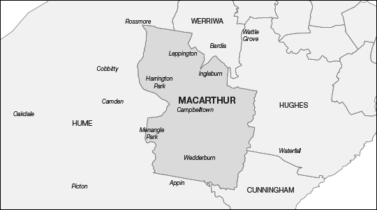
Macarthur
96 773
-6.48%
109 620
-0.83%
363 km2
Mackellar
104 264
0.76%
111 364
0.74%
233 km2
Macquarie
99 516
-3.83%
106 949
-3.25%
4 374 km2
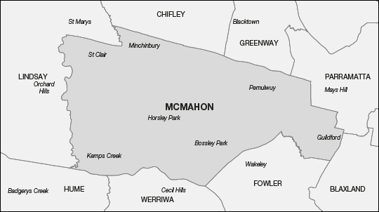
McMahon
104 256
0.75%
113 824
2.97%
173 km2
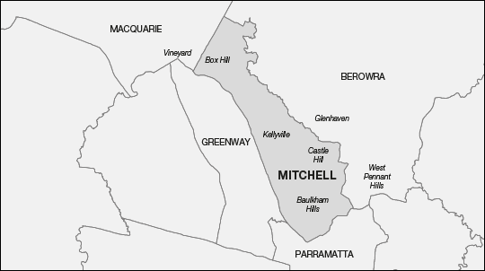
Mitchell
98 816
-4.51%
108 266
-2.06%
101 km2
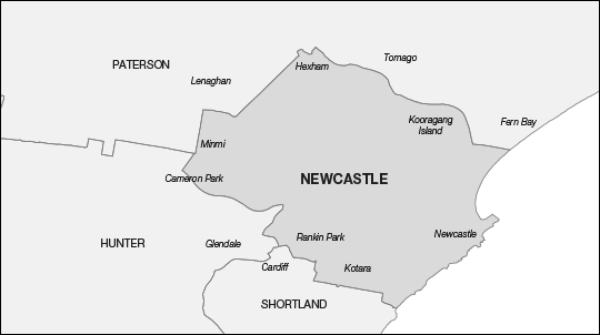
Newcastle
109 265
5.59%
113 025
2.25%
171 km2
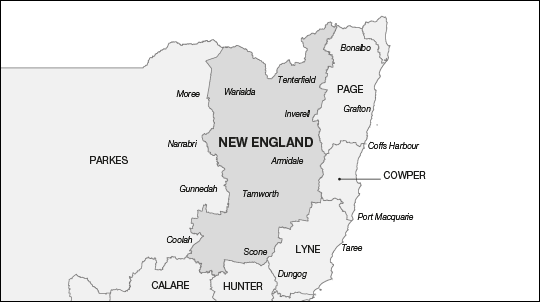
New England
107 179
3.57%
110 219
-0.29%
71 909 km2
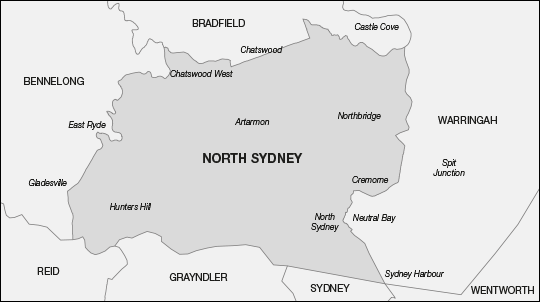
North Sydney
102 229
-1.21%
111 629
0.98%
53 km2
Page
111 117
7.38%
114 294
3.39%
19 342 km2
Parkes
103 020
-0.45%
107 110
-3.10%
402 513 km2
Parramatta
99 543
-3.81%
111 097
0.50%
57 km2
Paterson
104 954
1.42%
109 455
-0.98%
1 124 km2
Reid
101 429
-1.98%
112 739
1.99%
56 km2
Richmond
105 768
2.21%
107 403
-2.84%
2 148 km2
Riverina
105 008
1.48%
108 285
-2.04%
46 093 km2
Robertson
104 017
0.52%
110 181
-0.33%
980 km2
Shortland
106 161
2.59%
110 029
-0.46%
265 km2
Sydney
97 910
-5.38%
109 407
-1.03%
45 km2
Warringah
98 571
-4.74%
107 752
-2.52%
68 km2
Watson
102 790
-0.67%
113 268
2.47%
47 km2
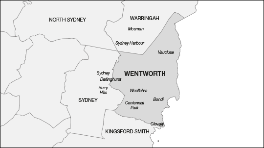
Wentworth
101 826
-1.60%
110 062
-0.43%
36 km2
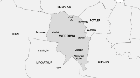
Werriwa
98 362
-4.95%
109 437
-1.00%
117 km2
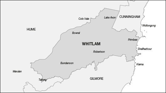
Whitlam
109 457
5.77%
113 026
2.25%
1 692 km2
The Committee’s redistribution proposal, as outlined previously, is discussed in greater detail in the paragraphs that follow. The proposed electoral divisions are dealt with in alphabetical order despite, as discussed previously, the proposed electoral divisions being drawn in a different order. Changes made to the Divisions of Richmond and Wentworth result in subsequent changes to almost all other electoral divisions. Statistical summaries of each proposed electoral division are provided in Appendix J.
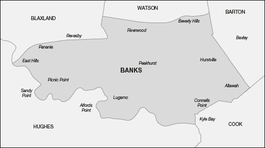
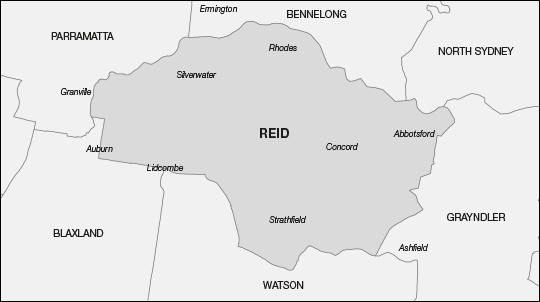
Proposed Division of Banks
The proposed Division of Banks shares boundaries with the proposed Divisions of Blaxland, Watson, Barton, Cook and Hughes – Figure G refers.
Figure G: Proposed Division of Banks
Boundary description: From Fairford Road along the M5 Motorway east to Kingsgrove Road; south to Stoney Creek Road; west to Croydon Road; south to Xenia Avenue and the Illawarra Railway line, Andover and Francis Streets and the Princes Highway; south-west to Terry Street and the eastern boundary of Connells Point reserve; south to the Georges River; north-west to the East Hills Railway line; east to Davies Road; north to Fairford Road at the M5 Motorway.
Projected enrolment in the existing Division of Banks is 109 653. This electoral division can therefore gain up to 4 758 electors from other electoral divisions, or transfer up to 2 980 electors to other electoral divisions, and remain within the acceptable numerical tolerances.
The Committee proposes that the Division of Banks gain 5 236 electors from the Division of Barton in the area of Kingsgrove, Roselands and Beverly Hills, and 15 129 electors from the Division of Hughes in the area of Revesby, Panania, East Hills, Picnic Point and Revesby Heights.
The Committee proposes that the Division of Banks transfer 8 509 electors to the proposed Division of Blaxland in the area of Padstow and Revesby, 5 034 electors to the proposed Division of Cook in the area of Kyle Bay, Blakehurst and Connells Point, and 3 704 electors to the proposed Division of Watson in the area of Punchbowl, Riverwood and Padstow.
The changes result in a projected enrolment for the proposed Division of Banks of 112 771 electors or a variation from the projected enrolment quota of plus 2.02 per cent.
Having determined the boundaries for the proposed Divisions of Hughes, Blaxland, Watson, Barton and Cook, the proposed Division of Banks meets the numerical requirements of the Electoral Act.
The Committee considers the proposed Division of Banks delivers clear, well-defined boundaries.
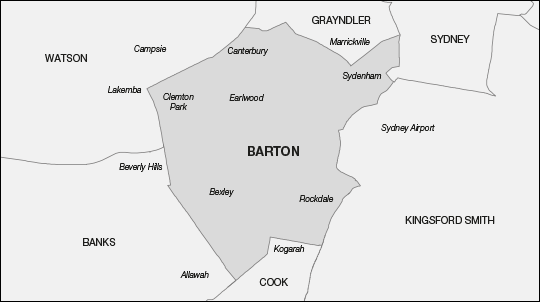
Proposed Division of Barton
The proposed Division of Barton shares boundaries with the proposed Divisions of Grayndler, Sydney, Kingsford Smith, Cook, Banks and Watson – Figure H refers.
Figure H: Proposed Division of Barton
Boundary description: From the intersection of Canterbury Road and Old Canterbury Road generally east along New Canterbury Road to Marrickville Road; south-east to Buckley Street; south to the spur railway line north of Fraser Park; south-east to the Illawarra Railway line; north-east to King Street; south to Barwon Park Road and the Sydney/Marrickville LGA boundary at the Alexandra Canal; south-west to Airport Drive and the Cooks River to the Botany Bay shoreline; south to President Avenue; west to the Princes Highway; south-west to Francis Street; north-west to Andover Street, the Illawarra Railway line, Xenia Avenue and Croydon Road to Stoney Creek Road; east to Kingsgrove Road; north to Canterbury Road; north-east to New Canterbury Road.
Projected enrolment in the existing Division of Barton is 108 883. This electoral division can therefore gain up to 5 528 electors from other electoral divisions, or transfer up to 2 210 electors to other electoral divisions, and remain within the acceptable numerical tolerances.
The Committee proposes that the Division of Barton gain 23 844 electors from the Division of Grayndler in the area of St Peters, Tempe, Marrickville South, Marrickville, Dulwich Hill, Hurlstone Park and Canterbury, and 5 579 electors from the Division of Watson in the area of Belmore South, Clemton Park, Canterbury and Campsie.
The Committee proposes that the Division of Barton transfer 5 236 electors to the proposed Division of Banks in the area of Kingsgrove and Beverly Hills, 22 502 electors to the proposed Division of Cook in the area of Kogarah, Beverley Park, Kogarah Bay, Carrs Park, Blakehurst, Sandringham, Sans Souci, Dolls Point, Ramsgate, Ramsgate Beach and Monterey, and 1 937 electors to the proposed Division of Watson in the area of Roselands and Kingsgrove.
The changes result in a projected enrolment for the proposed Division of Barton of 108 631 or a variation from the projected enrolment quota of minus 1.73 per cent.
The Committee acknowledges that the location of the proposed Division of Barton is impacted by the changes made to the electoral divisions located on the southern side of Sydney Harbour and along the east coast to Botany Bay.
The Committee notes that the proposed Division of Barton moves northwards as a result of the changes to the proposed Division of Grayndler. The northern boundary becomes New Canterbury Road and Marrickville Road. The Committee acknowledges that this boundary splits the Marrickville locality however it considers the boundary to be clear and well defined.
Changes to the proposed Divisions of Reid and Watson establish the north-western boundary along Canterbury Road and the western boundary along Kingsgrove Road.
The transfer of a sizeable number of electors results in the proposed Division of Barton being outside the numerical requirements of the Electoral Act.
The Committee therefore proposes to move the southern boundary from the Georges River to President Avenue and the Princes Highway.
The Committee considers that the proposed Division of Barton provides clear, strong and easily recognisable boundaries.
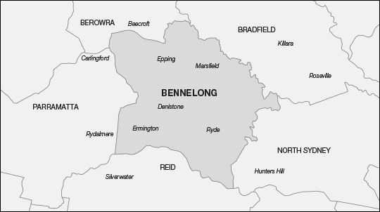
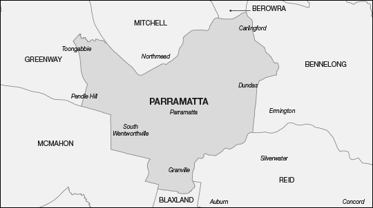
Proposed Division of Bennelong
The proposed Division of Bennelong shares boundaries with the proposed Divisions of Berowra, Bradfield, North Sydney, Reid and Parramatta – Figure I refers.
Figure I: Proposed Division of Bennelong
Boundary description: From Pennant Hills Road east along the M2 Motorway to Devlins Creek; north-east to the Lane Cove River; south-east to Pittwater Road, Victoria Road and Punt Road to the Parramatta River; west to Silverwater Road; north to Kissing Point Road; east to Stewart Street and Marsden Road; generally north to Pennant Hills Road; north to the M2 Motorway.
Projected enrolment in the existing Division of Bennelong is 110 876. This electoral division can therefore gain up to 3 535 electors from other electoral divisions, or transfer up to 4 203 electors to other electoral divisions, and remain within the acceptable numerical tolerances.
The Committee notes that the proposed Division of Bennelong meets the numerical requirements of the Electoral Act. On this occasion, the Committee proposes no elector movement for this electoral division.
Projected enrolment for the proposed Division of Bennelong therefore remains at 110 876 or a variation from the projected enrolment quota of plus 0.30 per cent.
However, given the opportunity to refine the boundaries, the Committee proposes making minor changes involving no elector movement to the boundary with the proposed Division of Reid by moving the water boundary to the middle of the Parramatta River.
The Committee believes the proposed Division of Bennelong offers clear, well-defined boundaries.
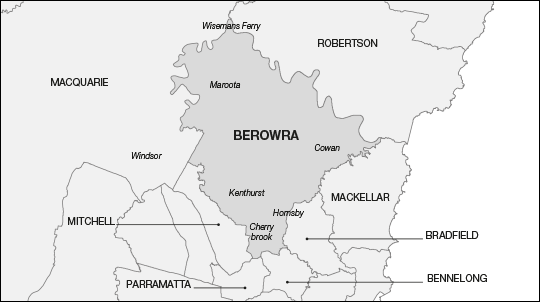
Proposed Division of Berowra
The proposed Division of Berowra shares boundaries with the proposed Divisions of Robertson, Mackellar, Bradfield, Bennelong, Parramatta, Mitchell and Macquarie – Figure J refers.
Figure J: Proposed Division of Berowra
Boundary description: From the Hawkesbury River at Wisemans Ferry to the eastern bank of Cowan Creek; south-west to the western branch of Cowan Creek and to Ku-Ring-Gai Chase Road; west to Belmont Parade; south to Lord Street; west to the Main Northern Railway line; south to Normanhurst Road and Osborn Road; south along the Hornsby/Ku-ring-gai LGA boundary, the Great North Walk Road and Lane Cove River to Devlins Creek; south-west to the M2 Motorway; west to Pennant Hills Road; south to North Rocks Road; north-west along the north-western boundary of Carlingford through Darling Mills State Forest and Excelsior Park; north to Taylor Street and Highs Road to Castle Hill Road; west to the Old Northern Road; north to Gilbert Road; north to Merrick Way and Gawain Court to Linksley Avenue; east to the watercourse through Citadel Creek Reserve; north-west to Cattai Creek; north-west to McClymonts Road; south-west to Maguires Road; generally west to Boundary Road; north-east to Cattai Creek at Cattai; west to the Hawkesbury River; north to Wisemans Ferry.
Projected enrolment in the existing Division of Berowra is 104 006. This electoral division must gain at least 2 667 electors, or up to 10 405 electors, from other electoral divisions to fall within the acceptable numerical tolerances.
The Committee proposes that the Division of Berowra gain 3 493 electors from the Division of Bradfield in the area of Asquith, Hornsby, Normanhurst, Thornleigh and Pennant Hills, and 3 362 electors from the Division of Mitchell in the area of Castle Hill.
The changes result in a projected enrolment for the proposed Division of Berowra of 110 861 or a variation from the projected enrolment quota of plus 0.29 per cent.
The Division of Berowra benefits from the Committee’s strategy of meeting the numerical requirements of the Electoral Act from within the Sydney Harbour–Hawkesbury Region. Cumulatively these changes result in the proposed Division of Berowra achieving this outcome and also better boundary definition.
The Committee believes the proposed Division of Berowra provides clear easily recognisable boundaries.
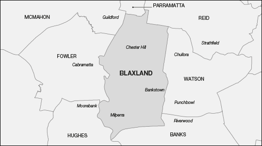
Proposed Division of Blaxland
The proposed Division of Blaxland shares boundaries with the proposed Divisions of Parramatta, Reid, Watson, Banks, Hughes, Fowler and McMahon – Figure K refers.
Figure K: Proposed Division of Blaxland
Boundary description: East from Woodville Road along Constance Street to Excelsior Street; north to Adam Street; east to Blaxcell Street; south to Dellwood Street; east to Clyde Street; north to Bennett Road; north-east to Mackay Road; north to Brussels Street; east to Duck River; north to Mona Street; east to Chisholm Road; south to Chiswick Road; west to Auburn Road; north to Water Street; east to Olympic Drive; south to Joseph Street, Rookwood Road, Stacey Street, Fairford Road and Davies Road to the East Hills Railway line; west to the Georges River; north to Prospect Creek and the Hume Highway; east to Woodville Road; north-east to Constance Street.
Projected enrolment in the existing Division of Blaxland is 112 764. This electoral division can therefore gain up to 1 647 electors from other electoral divisions, or transfer up to 6 091 electors to other electoral divisions, and remain within the acceptable numerical tolerances.
The Committee proposes that the Division of Blaxland gain 8 509 electors from the Division of Banks in the area of Revesby and Padstow, 10 224 electors from the Division of Hughes in the area of Revesby, Milperra, Panania and East Hills and 4 998 electors from the Division of Reid in the area of Auburn and Lidcombe.
The Committee proposes that the Division of Blaxland transfer 7 166 electors to the proposed Division of Fowler in the area of Yennora, Fairfield East and Carramar, 15 765 electors to the proposed Division of McMahon in the area of Woodpark, Guildford West, Guildford, Old Guildford, Smithfield and Yennora, and 3 818 electors to the proposed Division of Parramatta in the area of South Granville.
The changes result in a projected enrolment for the proposed Division of Blaxland of 109 746 or a variation from the projected enrolment quota of minus 0.72 per cent.
Having gained electors from the proposed Divisions of Reid, Banks and Hughes, the proposed Division of Blaxland is outside the numerical requirements of the Electoral Act and needs to transfer electors.
The Committee recognises that the proposed Division of Blaxland can only transfer electors to the proposed Divisions of Fowler and McMahon. Therefore, the Committee proposes to transfer electors in the Fairfield East/Carramar area to the proposed Division of Fowler and electors in the area between Woodville and Smithfield Roads generally at Guildford and Guildford West. These changes bring the proposed Division of Blaxland within the numerical tolerances.
The Committee believes the proposed Division of Blaxland provides very strong and clear boundaries.
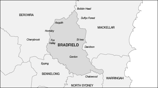
Proposed Division of Bradfield
The proposed Division of Bradfield shares boundaries with the proposed Divisions of Berowra, Mackellar, Warringah, North Sydney and Bennelong – Figure L refers.
Figure L: Proposed Division of Bradfield
Boundary description: South from Bobbin Head along the eastern branch of Cowan Creek and Middle Harbour; west and north-west along the middle of Middle Harbour and Scott Creek; then south along Eastern Valley Way and Warrane Road; west along Victoria Avenue; north along the Pacific Highway; generally west along Fullers Road; generally north-west along the Lane Cove River; then north along The Great North Walk and the Hornsby/Ku-ring-gai LGA boundary; then north along Osborn and Normanhurst Roads, the Main Northern Railway Line and Belmont Parade; east along Ku-Ring-Gai Chase Road; then south-east to Cowan Creek; north-east to the eastern branch of Cowan Creek.
Projected enrolment in the existing Division of Bradfield is 107 952. This electoral division can therefore gain up to 6 459 electors from other electoral divisions, or transfer up to 1 279 electors to other electoral divisions, and remain within the acceptable numerical tolerances.
The Committee proposes that the Division of Bradfield gain 6 281 electors from the Division of North Sydney in the area of Castle Cove and Chatswood, and two electors from the Division of Warringah at Roseville Bridge Marina.
The Committee proposes that the Division of Bradfield transfer 3 493 electors to the proposed Division of Berowra in the area of Asquith, Hornsby, Normanhurst, Thornleigh and Pennant Hills.
The Committee further proposes that the boundary with the proposed Division of Mackellar be moved to the middle of Middle Harbour north of Roseville Bridge, involving no elector movement and the boundary with the proposed Division of Warringah be also moved to the middle of Middle Harbour involving the two electors at Roseville Bridge Marina.
The changes result in a projected enrolment for the proposed Division of Bradfield of 110 742 or a variation from the projected enrolment quota of plus 0.18 per cent.
Having gained electors from the Division of North Sydney in line with its strategy of meeting the numerical requirements of the region from within, the Committee is able to move the boundary with the proposed Division of Berowra east to the Main Northern Railway line from Normanhurst Road to Ku-Ring-Gai Chase Road and to the Kur-ring-gai/Hornsby LGA boundary between Osborn Road and the Lane Cove River.
The Committee believes the proposed Division of Bradfield provides clear and strong boundaries.
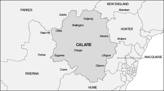
Proposed Division of Calare
The proposed Division of Calare shares boundaries with the proposed Divisions of Parkes, New England, Hunter, Macquarie, Hume and Riverina – Figure M refers.
Figure M: Proposed Division of Calare
Boundary description: Comprises the LGAs of Wellington, Mid-Western Regional, Lithgow, Oberon, Bathurst Regional, Blayney, Cabonne and Orange.
Projected enrolment in the existing Division of Calare is 106 573. This electoral division must gain at least 100 electors, or up to 7 838 electors, from other electoral divisions to fall within the acceptable numerical tolerances.
The Committee proposes that the Division of Calare gain 22 electors from the Division of Hume in the area of Canowindra, 2 064 electors from the Division of Hunter in the area of Kandos, Rylstone and Bylong, and 20 330 electors from the Division of Parkes in the area of Wellington and Mid-Western Regional LGAs.
The Committee proposes that the Division of Calare transfer 17 175 electors to the Division of Riverina in the Parkes and Forbes LGAs.
The changes result in a projected enrolment for the proposed Division of Calare of 111 814 or a variation from the projected enrolment quota of plus 1.15 per cent.
The abolition of the existing Division of Hunter results in the proposed Division of Calare moving east to gain the balance of the Mid-Western Regional LGA.
The Committee recognised that Wellington LGA has a strong community of interest with Dubbo, however changes made to the proposed Division of Parkes could not accommodate Wellington LGA. Consequently Wellington LGA was transferred to the proposed Division of Calare with whom it shares a community of interest, albeit to a lesser degree than that with Dubbo.
The result of these changes was the transfer of the LGAs of Parkes and Forbes to the proposed Division of Riverina.
In line with the Committee’s principle regarding LGAs in rural areas, the proposed Division of Calare is comprised of entire LGAs.
The Committee believes the proposed Division of Calare delivers strong and easily recognisable boundaries.
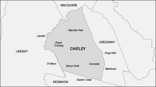
Proposed Division of Chifley
The proposed Division of Chifley shares boundaries with the proposed Divisions of Macquarie, Greenway, McMahon and Lindsay – Figure N refers.
Figure N: Proposed Division of Chifley
Boundary description: From Richmond Road along South Creek north-east to Bandon Road and the Blacktown Richmond Railway line; south-east to Third Avenue, Balmoral Street and Reservoir Road to the Great Western Highway; east to Ropes Creek; north-west to the Blacktown/Penrith LGA boundary; west to South Creek; north-east to Richmond Road.
Projected enrolment in the existing Division of Chifley is 116 049. This electoral division must transfer at least 1 638 electors, or up to 9 376 electors, to other electoral divisions to fall within the acceptable numerical tolerances.
The Committee proposes that the Division of Chifley gain 460 electors from the Division of Greenway in the area of Blacktown near the Ashlar Golf Course.
The Committee proposes that the Division of Chifley transfer 3 961 electors to the proposed Division of Greenway in that part of Blacktown between Flushcombe, Bungarribee and Reservoir Roads and the Great Western Highway, and 4 020 electors to the proposed Division of McMahon in the area of Minchinbury, Eastern Creek and Huntingwood.
The changes result in a projected enrolment for the proposed Division of Chifley of 108 528 or a variation from the projected enrolment quota of minus 1.82 per cent.
Noting the proposed Division of Chifley needs to transfer electors, and that the boundaries with the neighbouring proposed Divisions of Lindsay and Macquarie remain unchanged, the Committee proposes moving the southern boundary to the Great Western Highway. It also proposes moving the eastern boundary west to Reservoir Road away from the central business district of Blacktown.
The Committee also uses this opportunity to refine the boundary with the proposed Division of Greenway by using the Blacktown-Richmond Railway line for the length of that boundary.
The Committee regards the proposed Division of Chifley to be strong, clear and easily recognisable.
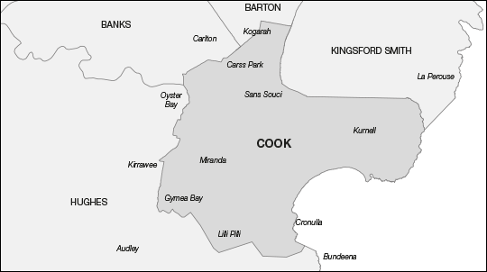
Proposed Division of Cook
The proposed Division of Cook shares boundaries with the proposed Divisions of Barton, Kingsford Smith, Hughes and Banks – Figure O refers.
Figure O: Proposed Division of Cook
Boundary description: From the Princes Highway at Kogarah east along President Avenue to Botany Bay; south along the shore line to the Georges River at Dolls Point and south-east to the Sutherland Shire LGA boundary and east to the northern tip of the Kurnell Peninsula; then generally south to the Hacking River; then generally west to Dents Creek; north along North West Arm and Hotham Roads to Kingsway; west to Princes Highway; north-east to the rear and west fenceline of Kirinari Hostel; west to Kareela Golf Course; north to the eastern shoreline of Oyster Bay; north across the Georges River to the eastern side of Connells Point Reserve to Terry Street; generally east to Princes Highway; then north-east to President Avenue.
Projected enrolment in the existing Division of Cook is 112 358. This electoral division can therefore gain up to 2 053 electors from other electoral divisions, or transfer up to 5 685 electors to other electoral divisions, and remain within the acceptable numerical tolerances.
The Committee proposes that the Division of Cook gain 5 034 electors from the Division of Banks in the area of Kyle Bay, Blakehurst and Connells Point, and 22 502 electors from the Division of Barton in the area of Kogarah, Beverley Park, Kogarah Bay, Carrs Park, Blakehurst, Sandringham, Sans Souci, Dolls Point, Ramsgate, Ramsgate Beach and Monterey.
The Committee proposes that the Division of Cook transfer 30 859 electors to the proposed Division of Hughes in the area of Bonnet Bay, Como, Jannali, Caravan Head, Oyster Bay, Kareela, Sutherland, Kirrawee, Loftus and Grays Point.
The changes result in a projected enrolment for the proposed Division of Cook of 109 035 or a variation from the projected enrolment quota of minus 1.36 per cent.
The Committee considers crossing the Georges River appropriate where strong transport routes exist in suitable areas. Therefore, the Committee proposes crossing the Georges River at the Captain Cook and Tom Uglys Bridges.
The Committee considers this is a reasonable and necessary approach to address the northward movement of the proposed Division of Barton, thereby allowing the proposed Division of Cook to acquire the areas of Kyle Bay and Blakehurst from the proposed Division of Banks, and Monterey and the Sans Souci peninsula from the proposed Division of Barton. The Committee considers that it would be unreasonable to maintain an artificial barrier with the strong pattern evident in the northward movement of electoral divisions.
The Committee regards the proposed Division of Cook provides clear and recognisable boundaries.
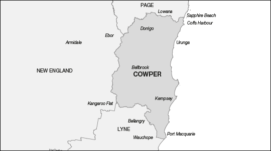
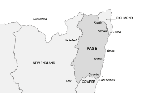
Proposed Division of Cowper
The proposed Division of Cowper shares boundaries with the proposed Divisions of Page, Lyne and New England – Figure P refers.
Figure P: Proposed Division of Cowper
Boundary description: Comprises the LGAs of Bellingen, Nambucca, Kempsey and parts of Coffs Harbour and Port Macquarie-Hastings LGAs. The northern boundary commences on the coast at an unnamed creek just north of Sapphire Crescent at Sapphire Beach; west to the Pacific Highway; north to the southern boundaries of the localities of Sapphire Beach, Bucca, Karangi, Coramba and Lowanna to the boundaries of Coffs Harbour, Bellingen, Nambucca and Kempsey LGAs to the northern boundary of Port Macquarie-Hastings LGA; east to the western boundaries of the locality of Gum Scrub and the southern boundary of the locality of Telegraph Point to the Pacific Highway; south to the northern boundary of the locality of Lake Innes; east through Lake Innes Nature Reserve and the northern boundary of Lake Innes locality and to the coast; north to the unnamed creek just north of Sapphire Crescent.
Projected enrolment in the existing Division of Cowper is 100 289. This electoral division must gain at least 6 384 electors, or up to 14 122 electors, from other electoral divisions to fall within the acceptable numerical tolerances.
The Committee proposes that the Division of Cowper gain 37 024 electors from the Division of Lyne in the southern part of Kempsey LGA and that part of Port Macquarie-Hastings LGA including Telegraph Point and Port Macquarie.
The Committee proposes that the Division of Cowper transfer 23 114 electors to the proposed Division of Page in the northern part of Coffs Harbour LGA from Lowanna, Coramba and Sapphire Beach, and its part of Clarence Valley LGA.
The changes result in a projected enrolment for the proposed Division of Cowper of 114 199 or a variation from the projected enrolment quota of plus 3.31 per cent.
The Committee acknowledges that the boundaries of the proposed Division of Cowper are dictated predominantly by the numerical requirements of the Electoral Act. The location of the proposed Division of Cowper mid-way through the coastal corridor extending from the New South Wales – Queensland border to the Newcastle region, limits the options available for constructing proposed boundaries.
As a result, there are less than optimal outcomes in terms of communities of interest. The proposed Division of Cowper contains the major centres of Coffs Harbour and Port Macquarie and therefore splits the two respective LGAs. The locality of Wauchope is also split from Port Macquarie. The proposed electoral division does however unite Kempsey LGA. The alternative involves crossing the Great Dividing Range.
Conscious of the need to avoid splitting the respective central business districts of Coffs Harbour and Port Macquarie, the Committee sought to define boundaries as far away from these centres as practicable.
The Committee considers the proposed Division of Cowper provides appropriately clear and identifiable boundaries by using LGA and locality boundaries combined with man-made and natural features.
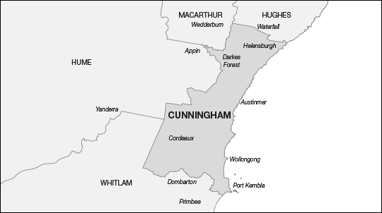
Proposed Division of Cunningham
The proposed Division of Cunningham shares boundaries with the proposed Divisions of Hughes, Whitlam, Hume and Macarthur – Figure Q refers.
Figure Q: Proposed Division of Cunningham
Boundary description: From the Sutherland Shire/Wollongong LGA boundary at Lake Woronora east to the coast; then south to the northern end of Windang Park at Primbee; west to Lake Illawarra; along the eastern and northern shoreline to the eastern end of Wollamai Park; south-east along Northcliffe Drive to Lake Heights Road; generally north to Flagstaff Road; east to eastern boundary of Cringila; north to Five Islands Road; north-west to the South Coast Railway line; south-west to the Moss Vale Unanderra Railway line; generally west to No. 15 Fire Road and Lake Avon to the Wollongong/Wingecarribee LGA boundary; generally north to the Wollongong/Wollondilly LGA boundary; north and east to O’Hares Creek; north-west to the Wollondilly/Campbelltown LGA boundary; east and north along the Wollongong/Campbelltown LGA boundary to Lake Woronora.
Projected enrolment in the existing Division of Cunningham is 109 306. This electoral division can therefore gain up to 5 105 electors from other electoral divisions, or transfer up to 2 633 electors to other electoral divisions, and remain within the acceptable numerical tolerances.
The Committee proposes that the Division of Cunningham gain 18 electors from the Division of Macarthur in the Darkes Forest area, and 8 275 electors from the existing Division of Throsby in the area of Port Kembla, Kemblawarra, Warrawong and Lake Heights.
The Committee proposes that the Division of Cunningham transfer 7 279 electors to the proposed Division of Hughes in the area of Bundeena, Maianbar, Audley, Heathcote, Waterfall and the Royal National Park, and 209 electors to the proposed Division of Whitlam in the area of Unanderra.
The changes result in a projected enrolment for the proposed Division of Cunningham of 110 111 or a variation from the projected enrolment quota of minus 0.39 per cent.
Wanting to keep the proposed Division of Cunningham out of the Sydney Metropolitan Area and entirely in the Illawarra region, the Committee transfers the balance of the Sutherland Shire LGA to the proposed Division of Hughes, thus moving south to the Wollongong LGA boundary. For the same reason, the Committee retains the western boundary with the proposed Divisions of Hume, Whitlam and Macarther, with the exception of Darkes Forest.
The transfer of electors to the proposed Division of Hughes results in the proposed Division of Cunningham needing to gain additional electors to bring it into numerical tolerance.
Therefore, the Committee moves the south east boundary into the proposed Division of Whitlam to the general area surrounding the locality of Warrawong.
The Committee believes that the proposed Division of Cunningham provides very strong and clear boundaries.
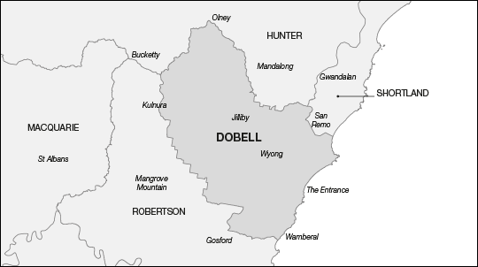
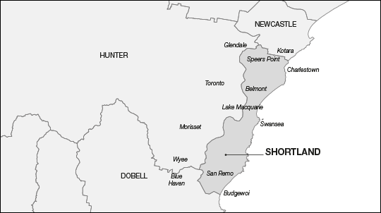
Proposed Division of Dobell
The proposed Division of Dobell shares boundaries with the proposed Divisions of Hunter, Shortland and Robertson – Figure R refers.
Figure R: Proposed Division of Dobell
Boundary description: From the eastern end of Budgewoi Lake south to Wamberal Lagoon inlet; then generally north-west along Ocean View Drive to The Entrance Road; west to Carlton Road; north to Clyde Road; generally north-west to Glennie Street; west to the Main Northern Railway line; generally north-east to the Gosford/Wyong LGA boundary; north-west to the Cessnock/Wyong LGA boundary; north-east to the Lake Macquarie/Wyong LGA boundary; south-east to the Pacific Highway; south-west to Wallarah Creek; south-east through Budgewoi Lake to the coast.
Projected enrolment in the existing Division of Dobell is 106 391. This electoral division must gain at least 282 electors, or up to 8 020 electors, from other electoral divisions to fall within the acceptable numerical tolerances.
The Committee proposes that the Division of Dobell gain 8 211 electors from the Division of Shortland in the area of Lake Haven, Charmhaven and Gorokan.
The Committee proposes that the Division of Dobell transfer 2 459 electors to the proposed Division of Robertson in the area of Wamberal.
The changes result in a projected enrolment for the proposed Division of Dobell of 112 143 or a variation from the projected enrolment quota of plus 1.45 per cent.
Although the proposed Division of Dobell is outside the numerical requirements of the Electoral Act, the Committee transfers the area between the Terrigal and Wamberal Lagoons into the proposed Division of Robertson in order to unite communities of interest.
This transfer of electors allows the Committee to move the northern boundary on the western side of Budgewoi Lake to Wallarah Creek, with the effect of uniting the localities of Gorokan and Charmhaven in the proposed Division of Dobell.
The Committee also uses the opportunity to move the water boundary through Budgewoi Lake from Wallarah Creek to the coast involving no elector movement.
The Committee considers the proposed Division of Dobell affords strong and clear boundaries.
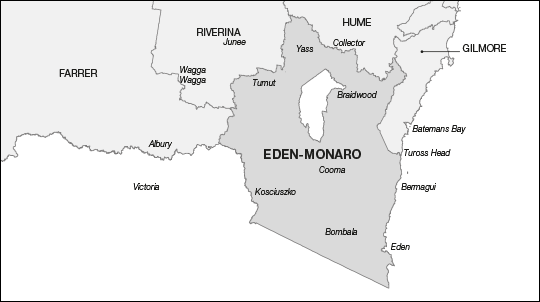
Proposed Division of Eden-Monaro
The proposed Division of Eden-Monaro shares boundaries with the proposed Divisions of Hume, Gilmore, Farrer and Riverina – Figure S refers.
Figure S: Proposed Division of Eden-Monaro
Boundary description: Comprises the LGAs of Yass Valley, Palerang, Queanbeyan City, Cooma-Monaro, Bega Valley, Bombala, Snowy River, Tumbarumba, Tumut, and part of Eurobodalla LGA from the Palerang/Eurobodalla LGA boundary at Wolla Creek through Deua National Park to Wamban Creek, Little Bumbo Creek through Moruya State Forest to Tuross Lake, around the northern shore to the coast.
Projected enrolment in the existing Division of Eden-Monaro is 104 154. This electoral division must gain at least 2 519 electors, or up to 10 257 electors, from other electoral divisions to fall within the acceptable numerical tolerances.
The Committee proposes that the Division of Eden-Monaro gain 14 658 electors from the Division of Hume in the Yass Valley and Palerang LGAs, and 10 512 electors from the Division of Riverina in the area of Tumut and Tumbarumba LGAs.
The Committee proposes that the Division of Eden-Monaro transfer 21 941 electors to the proposed Division of Gilmore in the Eurobodalla LGAs north of Tuross Head and Turlinjah.
The changes result in a projected enrolment for the proposed Division of Eden-Monaro of 107 383 or a variation from the projected enrolment quota of minus 2.86 per cent.
The Committee recognises that the proposed Division of Eden-Monaro is impacted by the shortfall of electors in the Illawarra region and its location in the south-eastern corner of the state. This shortfall results in the boundary with the proposed Division of Gilmore moving further south into the Eurobodalla LGA.
Despite receiving the LGAs of Tumut and Tumbarumba from the proposed Division of Riverina, the proposed Division of Eden-Monaro still requires further electors. The Committee proposes to transfer Yass Valley LGA and the balance of Palerang LGA from the existing Division of Hume in the north into the proposed division of Eden-Monaro.
The proposed division comprises entire LGAs with the exception of Eurobodalla.
The Committee believes the proposed Division of Eden-Monaro provides strong and easily recognisable boundaries.
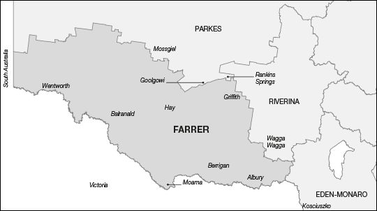
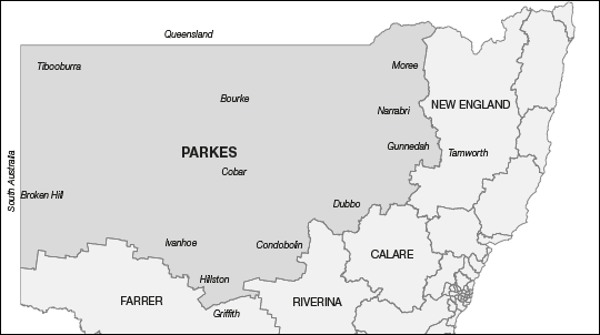
Proposed Division of Farrer
The proposed Division of Farrer shares boundaries with the proposed Divisions of Parkes, Riverina and Eden-Monaro – Figure T refers.
Figure T: Proposed Division of Farrer
Boundary description: Comprises the LGAs of Wentworth, Balranald, Hay, Griffith, Murrumbidgee, Leeton, Narrandera, Jerilderie, Urana, Lockhart, Greater Hume, Albury, Corowa, Berrigan, Conargo, Deniliquin, Murray and Wakool, and part of Carrathool LGA along the Mid Western Highway except around the localities of Rankins Springs and Goolgowi where the boundary follows local roads south of the towns.
Projected enrolment in the existing Division of Farrer is 97 030. This electoral division must gain at least 9 643 electors, or up to 17 381 electors, from other electoral divisions to fall within the acceptable numerical tolerances.
The Committee proposes that the Division of Farrer gain 30 481 electors from the Division of Riverina in the LGAs of Griffith, Leeton, Murrumbidgee and Narrandera and that part of Carrathool LGA generally south of the Mid Western Highway.
The Committee proposes that the Division of Farrer transfer 14 737 electors to the proposed Division of Parkes in the LGAs of Broken Hill, Central Darling and Unincorporated NSW, and three electors to the proposed Division of Riverina in the Fargunyah area.
The changes result in a projected enrolment for the proposed Division of Farrer of 112 771 or a variation from the projected enrolment quota of plus 2.02 per cent.
The transfer of Unincorporated NSW, Broken Hill and Central Darling LGAs to the proposed Division of Parkes requires the Committee to rebuild the proposed Division of Farrer to meet the numerical requirements of the Electoral Act.
This is achieved by transferring the entire LGAs of Murrumbidgee, Narrandera, Leeton and Griffith into the proposed Division of Farrer. Carrathool LGA is split as the proposed Division of Parkes requires additional electors to achieve numerical tolerance. This transfer acknowledges the shared community of interests between the Murrumbidgee, Narrandera, Leeton, Griffith and Carrathool LGAs.
The Committee notes the split in Carrathool LGA is made generally along the Mid Western Highway with that part of the LGA generally south of the highway being transferred into the proposed Division of Farrer.
The Committee considers that despite this split, the proposed Division of Farrer delivers clear, strong boundaries based predominantly on LGAs and in part, mostly the Mid Western Highway.
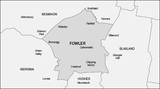
Proposed Division of Fowler
The proposed Division of Fowler shares boundaries with the proposed Divisions of McMahon, Blaxland, Hughes and Werriwa – Figure U refers.
Figure U: Proposed Division of Fowler
Boundary description: From Smithfield Road south-east along Prospect Creek to Pine Road north of Bell Crescent; south to the Cabramatta Granville Railway line and Fairfield Street; east to Woodville Road; south-west to the Hume Highway; west to Prospect Creek; south to the Georges River at Georges Hall and west to Davy Robinson Drive; north to Newbridge Road; west to the Georges River at Liverpool; south to the M5 Motorway; west to Liverpool Street and Calabro Avenue; north to Hoxton Park Road; west to Maxwells Creek; north to Cabramatta Creek and Elizabeth Drive; north-west to Smithfield Road; north-east to Prospect Creek.
Projected enrolment in the existing Division of Fowler is 110 903. This electoral division can therefore gain up to 3 508 electors from other electoral divisions, or transfer up to 4 230 electors to other electoral divisions, and remain within the acceptable numerical tolerances.
The Committee proposes that the Division of Fowler gain 7 166 electors from the Division of Blaxland in the area of Yennora, Fairfield East and Carramar, 13 905 electors from the Division of Hughes in the area of Chipping Norton, Warwick Farm and Liverpool, 28 195 electors from the Division of McMahon in the area of Fairfield, Fairfield West, Fairfield Heights, Canley Heights, Canley Vale, Prairiewood and Smithfield, and 5 460 electors from the Division of Werriwa in the area of Liverpool and Liverpool South.
The Committee proposes that the Division of Fowler transfer 5 015 electors to the proposed Division of McMahon in the area of Edensor Park, and 48 312 electors to the proposed Division of Werriwa in the area of Ashcroft, Cartwright, Miller, Sadleir, Heckenberg, Busby, Green Valley, Hinchinbrook, Middleton Grange, Elizabeth Hills, Cecil Hills, Bonnyrigg and West Hoxton.
The changes result in projected enrolment for the proposed Division of Fowler of 112 302 or a variation from the projected enrolment quota of plus 1.59 per cent.
The changes made to the boundaries for the proposed Divisions of Blaxland, Hughes and McMahon result in the proposed Division of Fowler gaining a considerable number of electors from these electoral divisions. Consequently, the proposed Division of Fowler is outside the numerical requirements of the Electoral Act.
The Committee, recognising that the only electoral division to which the proposed Division of Fowler can transfer electors is the proposed Division of Werriwa, proposes to transfer the area south of Elizabeth Drive and west of Cabramatta Creek and Maxwells Creek to the proposed Division of Werriwa. However, the Committee, noting that the locality of Liverpool is still split, proposes to move the boundary south of Hoxton Park Road and west of the Georges River.
As the proposed Division of Fowler still remains outside of numerical tolerance, the Committee further proposes to transfer the Edensor Park area to the proposed Division of McMahon noting that this change achieves stronger boundaries along Elizabeth Drive and Smithfield Road.
The Committee believes the proposed Division of Fowler delivers very strong and clear boundaries.
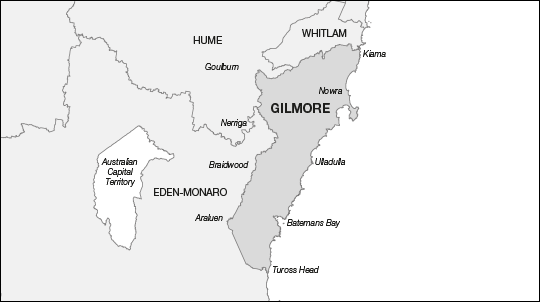
Proposed Division of Gilmore
The proposed Division of Gilmore shares boundaries with the proposed Divisions of Whitlam, Eden-Monaro and Hume – Figure V refers.
Figure V: Proposed Division of Gilmore
Boundary description: Comprises the LGAs of Kiama, Shoalhaven and part of Eurobodalla LGA from the Palerang/Eurobodalla LGA boundary at Wolla Creek through Deua National Park to Wamban Creek, Little Bumbo Creek through Moruya State Forest to Tuross Lake, around the northern shore to the coast.
Projected enrolment in the existing Division of Gilmore is 105 336. This electoral division must gain at least 1 337 electors, or up to 9 075 electors, from other electoral divisions to fall within the acceptable numerical tolerances.
The Committee proposes that the Division of Gilmore gain 21 941 electors from the Division of Eden-Monaro in the Eurobodalla LGA north of, and including, Tuross Head and Turlinjah.
The Committee proposes that the Division of Gilmore transfer 16 047 electors to the proposed Division of Whitlam in the LGA of Shellharbour.
These changes result in a projected enrolment for the proposed Division of Gilmore of 111 230 or a variation from the projected enrolment quota of plus 0.62 per cent.
The Committee’s principle of moving the Illawarra out of the Greater Sydney Region contributes to the cumulative shortfall of electors in the Illawarra region. This shortfall moves all Illawarra coastal divisions south. As a result, the proposed Division of Gilmore contains the entire LGAs of Kiama and Shoalhaven. The Committee notes that Eurobodalla LGA is already split and therefore proposes to draw the boundary in this region through Deua National Park to Tuross Lake. The selection of this area allows the Committee to reduce the potential impact on electors in the more rural parts of the electoral division.
The Committee is unable to move the Southern Highlands into the proposed Division of Gilmore because transport links through Macquarie Pass would not be accessible as the proposed Division of Whitlam would need to move too far south to meet the numerical requirements of the Electoral Act. The Committee considered the alternate option provided by Nowra Road. However the Committee considers that this alternative does not provide an adequate connection between the Southern Highlands and the Shoalhaven coast.
The Committee believes the proposed Division of Gilmore offers strong and easily recognisable boundaries.
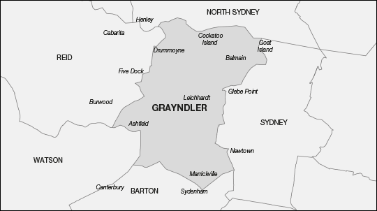
Proposed Division of Grayndler
The proposed Division of Grayndler shares boundaries with the proposed Divisions of North Sydney, Sydney, Barton, Watson and Reid – Figure W refers.
Figure W: Proposed Division of Grayndler
Boundary description: From the middle of the Parramatta River off Howley Park at Drummoyne east to, but not including, Goat Island; generally south and west through Johnstons Bay and Rozelle Bay to Johnstons Creek; south to Wigram Road; south-west to Booth Street; south to Mallett Street and Parramatta Road; west to Denison Street; south to Kilner Lane; west to Cardigan Lane; south to Salisbury Road; east to Kingston Road; south to Railway Avenue; south to Liberty Street; south to the Main Suburban Railway line; south-east to King Street; generally south to the Illawarra Railway line; south-west to the spur railway line north of Fraser Park; north-west to Marrickville Road at Buckley Street; north-west to New Canterbury Road; generally west to Old Canterbury Road; north-east to Prospect Road; north to Carlton Crescent; west to Liverpool Road; generally west to Frederick Street; north-east to Parramatta Road and Wattle Street; north-east to Ramsay Road; north-west to First Avenue; east to Park Road; north to Barnstaple Road; east to Ingham Avenue; north to Lyons Road; east to Sibbick Street; north to Byrne Avenue; east to eastern end of Lysaght Park; north-east through Five Dock Bay to the Parramatta River.
Projected enrolment in the existing Division of Grayndler is 115 074. This electoral division must transfer at least 663 electors, or up to 8 401 electors, to other electoral divisions to fall within the acceptable numerical tolerances.
The Committee proposes that the Division of Grayndler gain 14 468 electors from the Division of Reid in the area of Drummoyne, Russell Lea, Rodd Point and Rodd Island, and 25 455 electors from the Division of Sydney in the area of Birchgrove, Balmain, Balmain East, Rozelle, Lilyfield, Annandale and Cockatoo Island.
The Committee proposes that the Division of Grayndler transfer 23 844 electors to the proposed Division of Barton in the area of St Peters, Tempe, Marrickville South, Marrickville, Dulwich Hill, Hurlstone Park and Canterbury, 3 454 electors to the proposed Division of Reid in the area of Croydon and Burwood, 3 964 electors to the Division of Sydney in the area of Camperdown and Newtown, and 11 402 electors to the proposed Division of Watson in the area of Canterbury, Ashbury and Ashfield.
The Committee further proposes that the boundary with the proposed Division of North Sydney be aligned to the middle of Sydney Harbour.
The changes result in a projected enrolment for the proposed Division of Grayndler of 112 333 or a variation from the projected enrolment quota of plus 1.62 per cent.
As the proposed Division of Grayndler is the only electoral division to which the proposed Division of Sydney can transfer surplus electors, the proposed Division of Grayndler has to transfer a significant number of electors to meet the numerical requirements of the Electoral Act.
Due to changes to other electoral divisions, the proposed Division of Grayndler needs to transfer electors to the proposed Division of Barton in the area south of Marrickville, and the proposed Division of Watson in the area west of Summer Hill. These transfers result in the proposed Division of Grayndler requiring additional electors to meet the numerical requirements of the Electoral Act. Consequently, the Drummoyne peninsula is the only area that can provide the required elector numbers.
These changes result in the proposed Division of Grayndler moving north to Sydney Harbour, and the Parramatta River, east into the Balmain Peninsula and into the eastern part of the Drummoyne peninsula.
The Committee considers the proposed Division of Grayndler is defined by clear and acceptable boundaries.
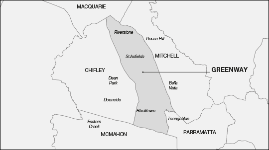
Proposed Division of Greenway
The proposed Division of Greenway shares boundaries with the proposed Divisions of Macquarie, Mitchell, Parramatta, McMahon and Chifley – Figure X refers.
Figure X: Proposed Division of Greenway
Boundary description: From the Blacktown Richmond Railway line at Bandon Road, Vineyard, north-east to Windsor Road; south-east to Old Windsor Road; south-east to Toongabbie Creek; generally west to the Main Western Railway line; south to Pendle Way; south to Great Western Highway; generally west to Reservoir Road; north to Balmoral Street and Third Avenue to the Blacktown Richmond Railway line; north-west to Bandon Road.
Projected enrolment in the existing Division of Greenway is 115 990. This electoral division must transfer at least 1 579 electors, or up to 9 317 electors, to other electoral divisions to fall within the acceptable numerical tolerances.
The Committee proposes that the Division of Greenway gain 3 961 electors from the Division of Chifley in the area of Blacktown between Flushcombe, Bungarribee and Reservoir Roads and the Great Western Highway.
The Committee proposes that the Division of Greenway transfer 460 electors to the proposed Division of Chifley in the area near the Ashlar Golf Course, and 7 848 electors to the proposed Division of Parramatta in the area of Toongabbie, Pendle Hill and Pendle Hill South.
The Committee further proposes that the boundary with the proposed Division of Mitchell be aligned to the new part of Windsor Road at the Annangrove Road exit at Rouse Hill, involving no elector movement.
The changes result in a projected enrolment for the proposed Division of Greenway of 111 643 or a variation from the projected enrolment quota of plus 1.00 per cent.
Changes to the boundary between the proposed Divisions of Greenway and Chifley transfer electors into the proposed Division of Greenway. This results in the proposed electoral division moving outside the numerical requirements of the Electoral Act. The Committee therefore proposes to transfer the electors in the area of Toongabbie to the proposed Division of Parramatta. Further, in the interests of defining stronger boundaries, the Committee proposes to align the Greenway/Mitchell electoral boundary to the new alignment of Windsor Road.
The Committee believes the proposed Division of Greenway delivers very strong and clear boundaries.
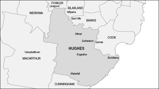
Proposed Division of Hughes
The proposed Division of Hughes shares boundaries with the proposed Divisions of Fowler, Blaxland, Banks, Cook, Cunningham, Macarthur and Werriwa – Figure Y refers.
Figure Y: Proposed Division of Hughes
Boundary description: From the Georges River bridge at Liverpool east along Newbridge Road to Davy Robinson Drive; south to the Georges River; generally south-east to the eastern shoreline of Oyster Bay; south to Kareela Golf Course; south to Box Road; east to the western and then the southern fenceline of Kirinari Hostel; east to the Princes Highway; south-west to Kingsway; east to Hotham Road; south to North West Arm Road; south to Dents Creek; south to Hacking River; south-east to the coast; south-west to the Sutherland Shire/Wollongong LGA boundary; generally west to the Sutherland Shire/Campbelltown LGA boundary; generally north and west to the Georges River; generally north to Newbridge Road.
Projected enrolment in the existing Division of Hughes is 109 987. This electoral division can therefore gain up to 4 424 electors from other electoral divisions, or transfer up to 3 314 electors to other electoral divisions, and remain within the acceptable numerical tolerances.
The Committee proposes that the Division of Hughes gain 30 859 electors from the Division of Cook in the area of Bonnet Bay, Como, Jannali, Caravan Head, Oyster Bay, Kareela, Sutherland, Kirrawee, Loftus and Grays Point, and 7 279 electors from the Division of Cunningham in the area of Bundeena, Maianbar, Audley, Heathcote, Waterfall and the Royal National Park.
The Committee proposes that the Division of Hughes transfer 15 129 electors to the proposed Division of Banks in the area of Revesby, Panania, East Hills, Picnic Point and Revesby Heights, 10 224 electors to the proposed Division of Blaxland in the area of Revesby, Panania, East Hills and Milperra, and 13 905 electors to the proposed Division of Fowler in the area of Chipping Norton, Warwick Farm and Liverpool.
The changes result in a projected enrolment for the proposed Division of Hughes of 108 867 or a variation from the projected enrolment quota of minus 1.52 per cent.
The general movement north-east of electoral divisions in this area results in the proposed Division of Hughes moving outside the numerical requirements of the Electoral Act and therefore needing to transfer electors.
With the boundary established for the proposed Division of Cook, and in line with keeping Illawarra electoral divisions within the Illawarra region, the Committee must move the proposed Division of Hughes to the east to gain the balance of Sutherland LGA.
As a result, the Committee proposes to transfer electors east of the Georges River to the proposed Divisions of Banks and Blaxland.
Recognising the strength of the Georges River as a divisional boundary, the Committee is reluctant to transfer electors west into the proposed Division of Werriwa. Consequently, the Committee proposes transferring electors in the area north of Newbridge Road to the proposed Division of Fowler. This change facilitates uniting the Liverpool locality.
These changes bring the proposed Division of Hughes within the numerical requirements of the Electoral Act.
The Committee believes the proposed Division of Hughes provides clear and strong boundaries.
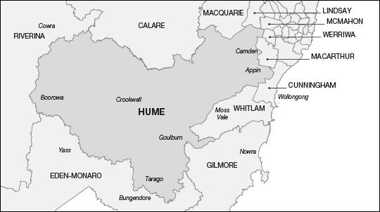
Proposed Division of Hume
The proposed Division of Hume shares boundaries with the proposed Divisions of Calare, Macquarie, Lindsay, McMahon, Werriwa, Macarthur, Cunningham, Whitlam, Gilmore, Eden-Monaro and Riverina – Figure Z refers.
Figure Z: Proposed Division of Hume
Boundary description: Comprises the LGAs of Boorowa, Upper Lachlan Shire, Goulburn Mulwaree, part Wingecarribee LGA west of the Hume Motorway north to Church Avenue, then west of the Old Hume Highway and No. 3B Fire Road, Nepean Lake and the Nepean River to the Wingecarribee/Wollondilly LGA boundary; part Wollondilly LGA south and east of Lake Burragorang but excluding the Darkes Forest area; part Camden LGA south of Narellan Road and west of the Northern Road; part Liverpool LGA west of Kemps Creek; part Penrith LGA south of the water pipeline between The Northern Road and the Nepean River at Wallacia.
Projected enrolment in the existing Division of Hume is 107 397. This electoral division can therefore gain up to 7 014 electors from other electoral divisions, or transfer up to 724 electors to other electoral divisions, and remain within the acceptable numerical tolerances.
The Committee proposes that the Division of Hume gain 47 569 electors from the Division of Macarthur in the area of Badgerys Creek, Bringelly, Rossmore, Greendale, Luddenham, Wallacia, Warragamba, Silverdale, Cobbitty, Ellis Lane, Kirkham, Grasmere, Bickley Vale, Camden South, Camden Park, Camden, Elderslie, Spring Farm, Mount Annan, Narellan Vale, Narellan, Cawdor, Menangle, Douglas Park and Appin.
The Committee proposes that the Division of Hume transfer 22 electors to the proposed Division of Calare in the area of Canowindra, 14 658 electors to the proposed Division of Eden-Monaro in the Yass Valley and Palerang LGAs, 29 329 electors to the proposed Division of Riverina in the LGAs of Weddin, Cowra, Young, Cootamundra and Harden, and 2 981 electors to the proposed Division of Whitlam in the area of Exeter, Bundanoon, Penrose and Wingello.
The changes result in a projected enrolment for the proposed Division of Hume of 107 976 or a variation from the projected enrolment quota of minus 2.32 per cent.
With the transfer of electors to the proposed Divisions of Riverina in the west, Eden-Monaro in the south and Whitlam in the east, the proposed Division of Hume requires a substantial number of electors to meet the numerical requirements of the Electoral Act.
Having established the boundaries the proposed Division of Hume shares with other rural and provincial electoral divisions, the Division of Hume could gain electors only by continuing the north-east movement of electoral divisions towards the Sydney Metropolitan Area through the proposed Division of Macarthur. The Committee notes that this northward movement was in evidence in the two most recent redistributions of New South Wales.
The Committee therefore proposes extending the northern boundary with the proposed Division of Macarthur north to the Wollondilly/Campbelltown LGA boundary, Narellan Road, the Northern Road Bringelly Road and Kemps Creek to the existing southern boundary of the proposed Divisions of Lindsay and McMahon.
The Committee believes the proposed Division of Hume provides strong and clear boundaries.
Proposed Division of Hunter (currently the Division of Charlton)
The proposed Division of Hunter shares boundaries with the proposed Divisions of New England, Lyne, Paterson, Newcastle, Shortland, Dobell, Robertson, Macquarie and Calare – Figure AA refers.
Figure AA: Proposed Division of Hunter
Boundary description: From the Hunter River at Greta west to Orient Street south of Valentine Close; south to the New England Highway; south-east to the Cessnock/Maitland LGA boundary; south-east to the Hunter Expressway; south-east to the eastern boundary of the localities of Keinbah, Lovedale, Nulkaba, Cessnock; east to the northern boundary of the localities of Aberdare, Kearsley and Elrington; east to Leggetts Drive; south to White Bridge Road; then generally east to Cessnock/Lake Macquarie LGA boundary; generally east to the Pacific Motorway; south-west to the Newcastle Link Road; generally east to Lake Road; south-west to Reservoir Road; south-east to Lowry Street; south-west to Main Road; south-east to the Main Northern Railway line; generally west to Cockle Creek; south to Lake Macquarie; generally south to the Lake Macquarie/Wyong LGA boundary; then following the outer boundary of Lake Macquarie, Cessnock, Singleton, Muswellbrook LGAs to the Hunter River.
Projected enrolment in the existing Division of Charlton is 103 128. This electoral division must gain at least 3 545 electors, or up to 11 283 electors, from other electoral divisions to fall within the acceptable numerical tolerances.
The Committee proposes that the Division of Charlton gain 52 020 electors from the existing Division of Hunter in Cessnock, Singleton and Muswellbrook LGAs.
The Committee proposes that the Division of Charlton transfer 26 482 electors to the proposed Division of Newcastle in the area of Cardiff Heights, Glendale, Lambton, New Lambton Heights, Rankin Park, Elermore Vale, Jesmond, Wallsend, Maryland, Fletcher and Minmi. The Committee further proposes to transfer 17 669 electors to the proposed Division of Shortland in the area of Speers Point, Boolaroo, Cardiff, Macquarie Hills, Lakelands, Cardiff South, Garden Suburb, Argenton and Warners Bay.
The Committee notes the proposed electoral division is comprised of both the existing Divisions of Charlton and Hunter, with the Division of Hunter contributing 46.87 per cent and the Division of Charlton contributing 53.13 per cent of itself to the proposed electoral division.
Following the guidelines on naming electoral divisions, the Committee acknowledges that the electoral division that contributes the most electors to the new electoral division would also provide the name. However, the guidelines also provide that where the socio-demographic nature of the electoral division in question changes significantly, the Committee can override the numerical formula. The Committee believes that is the case here: the proposed electoral division has changed from a provincial nature to become more rural in nature by gaining the LGAs of Cessnock, Singleton and Muswellbrook. The Committee also notes that ‘Hunter’ is a Federation name.
The Committee believes that the breadth of change to the proposed electoral division is such that it is appropriate to rename the proposed electoral division as ‘Hunter’.
The changes result in a projected enrolment for the proposed Division of Hunter of 110 997 or a variation from the projected enrolment quota of plus 0.41 per cent.
The Committee believes the proposed Division of Hunter provides strong and well defined boundaries.
Proposed Division of Kingsford Smith
The proposed Division of Kingsford Smith shares boundaries with the proposed Divisions of Sydney, Wentworth, Cook and Barton – Figure AB refers.
Figure AB: Proposed Division of Kingsford Smith
Boundary description: From Southern Cross Drive along Dacey Avenue east to Alison Road; south-east to King Street; east to Wentworth Street; north to Stanley Street; east to Avoca Street; south to Frenchmans Road; east to Clovelly Road; generally south-east to Walker Avenue at Clovelly; east to the coast; generally south to Botany Bay and Cape Solander; north to the northern tip of the Kurnell Peninsula; west to the Georges River at Dolls Point; north along the shoreline to the Cooks River; generally north to the Alexandra Canal; north-east to the bridge at Ricketty Street; east to the edge of the canal; north to the extension of Gardeners Road; east to Southern Cross Drive; generally north to Dacey Avenue.
Projected enrolment in the existing Division of Kingsford Smith is 112 719. This electoral division can therefore gain up to 1 692 electors from other electoral divisions, or transfer up to 6 046 electors to other electoral divisions, and remain within the acceptable numerical tolerances.
The Committee notes the Division of Kingsford Smith meets the numerical requirements of the Electoral Act. On this occasion, the Committee proposes no elector movement for this electoral division.
Projected enrolment for proposed Division of Kingsford Smith therefore remains at 112 719 or a variation from the projected enrolment quota of plus 1.97 per cent.
The Committee proposes that the Division of Kingsford Smith remains unchanged. Although it borders the proposed Division of Wentworth which must transfer surplus electors, the Committee prefers that these electors can be transferred to the neighbouring proposed Division of Sydney which must also undergo changes to its boundaries. The Committee reasoned that this approach would help limit the number of electors changing electoral divisions.
The Committee considers the proposed Division of Kingsford Smith has strong and clearly defined boundaries.
Proposed Division of Lindsay
The proposed Division of Lindsay shares boundaries with the proposed Divisions of Macquarie, Chifley, McMahon and Hume – Figure AC refers.
Figure AC: Proposed Division of Lindsay
Boundary description: From the Nepean River at Agnes Banks east along Springwood Road to the Penrith/Hawkesbury LGA boundary; south-west to The Driftway and Blacktown Road; south-west to South Creek; generally south-west to the Blacktown LGA boundary; east to Ropes Creek; south-east to the Western Motorway; west to South Creek; south to Elizabeth Drive; west to The Northern Road; north-west to Littlefields Road; north-west to the water pipeline; south-west to the Nepean River; then along the Nepean River to the Penrith/Blue Mountains LGA boundary; north to the Nepean River; north to Springwood Road.
Projected enrolment in the existing Division of Lindsay is 112 273. This electoral division can therefore gain up to 2 138 electors from other electoral divisions, or transfer up to 5 600 electors to other electoral divisions, and remain within the acceptable numerical tolerances.
The Committee notes the Division of Lindsay meets the numerical requirements of the Electoral Act. On this occasion, the Committee proposes no elector movement for this electoral division.
Projected enrolment for proposed Division of Lindsay remains at 112 273 or a variation from the projected enrolment quota of plus 1.57 per cent.
However, given the opportunity to refine the boundaries, the Committee proposes making minor changes involving no elector movement to the boundaries with the proposed Division of Macquarie along the Nepean River at Yarramundi.
The Committee considers the proposed Division of Lindsay delivers clear and well recognised boundaries.
Proposed Division of Lyne
The proposed Division of Lyne shares boundaries with the proposed Divisions of Cowper, Paterson, Hunter and New England – Figure AD refers.
Figure AD: Proposed Division of Lyne
Boundary description: Comprises the entire LGAs of Greater Taree, Gloucester, Dungog and Great Lakes, and part of the LGAs of Port Macquarie-Hastings, Maitland and Port Stephens. In the LGA of Port Macquarie-Hastings the boundary follows the western boundaries of the locality of Gum Scrub and the southern boundary of the locality of Telegraph Point to the Pacific Highway, then the northern boundary of the locality of Lake Innes, then east through Lake Innes Nature Reserve to the northern boundary of Lake Innes locality and to the coast. The southern boundary follows the Hunter River and the Williams River to the northern boundary of Raymond Terrace; east to the Pacific Highway; north-east to the southern boundary of the Wallaroo State Forest; east to Morton Road and Cook Drive; north to the northern boundary of the Medowie Conservation Area at Reedy Creek; east to Reedy Creek; generally south-east to the middle of Port Stephens and the coast.
Projected enrolment in the existing Division of Lyne is 99 398. This electoral division must gain at least 7 275 electors, or up to 15 013 electors, from other electoral divisions to fall within the acceptable numerical tolerances.
The Committee proposes that the Division of Lyne gain 44 724 electors from the Division of Paterson including the entire Dungog and the Great Lakes LGAs and part of the Maitland and the Port Stephens LGAs.
The Committee proposes that the Division of Lyne transfer 37 024 electors to the proposed Division of Cowper in the southern part of Kempsey LGA and part of Port Macquarie-Hastings LGA including Telegraph Point and Port Macquarie.
The changes result in a projected enrolment for the proposed Division of Lyne of 107 098 or a variation from the projected enrolment quota of minus 3.12 per cent.
The changes to the electoral divisions north of the proposed Division of Lyne necessitate the movement into this electoral division of electors from either the Division of Paterson or the existing Division of Hunter. The Committee, having already established that it did not want to cross the Great Dividing Range on the north coast, and noting the community of interest between the LGAs of Greater Taree and Gloucester with the LGAs to the south, determines to build the Division of Lyne by transferring electors from the proposed Division of Paterson.
As a result, the Committee proposes transferring the LGAs of Dungog and Great Lakes, and the northern part of the LGAs of Maitland and Port Stephens to the proposed Division of Lyne.
The Committee believes that the proposed Division of Lyne, although further splitting the already split Maitland and Port Stephens LGAs, has clearly defined and strong boundaries.
Proposed Division of Macarthur
The proposed Division of Macarthur shares boundaries with the proposed Divisions of Werriwa, Hughes, Cunningham and Hume – Figure AE refers.
Figure AE: Proposed Division of Macarthur
Boundary description: From The Northern Road east along Bringelly Road to Cowpasture Road; south to Camden Valley Way and to Denham Court Road; south-east to Campbelltown; south to Williamson Road; north-east to Henderson Road; south-east along the locality boundary between Ingleburn and Macquarie Fields to the Georges River at Long Point; south along the Campbelltown/Sutherland Shire LGA boundary and the Campbelltown/Wollongong LGA boundary and west and north along the Campbelltown/Wollondilly LGA boundary to the Campbelltown/Camden LGA boundary; north to Narellan Road; north-west to The Northern Road north to Bringelly Road.
Projected enrolment in the existing Division of Macarthur is 113 762. This electoral division can therefore gain up to 649 electors from other electoral divisions, or transfer up to 7 089 electors to other electoral divisions, and remain within the acceptable numerical tolerances.
The Committee proposes that the Division of Macarthur gain 43 445 electors from the Division of Werriwa in the area of Leppington, Denham Court, Varroville, Kearns, Raby, Eschol Park, Claymore, Eagle Vale, Minto, St Andrews, Minto Heights, Bow Bowing, Ingleburn and Catherine Field.
The Committee proposes that the Division of Macarthur transfer 18 electors to the proposed Division of Cunningham in the Darkes Forest area, and 47 569 electors to the proposed Division of Hume in the area of Badgerys Creek, Bringelly, Rossmore, Greendale, Luddenham, Wallacia, Warragamba, Silverdale, Cobbitty, Ellis Lane, Kirkham, Grasmere, Bickley Vale, Camden South, Camden Park, Camden, Elderslie, Spring Farm, Mount Annan, Narellan Vale, Narellan, Cawdor, Menangle, Douglas Park and Appin.
The changes result in a projected enrolment for the proposed Division of Macarthur of 109 620 or a variation from the projected enrolment quota of minus 0.83 per cent.
Having determined the boundaries for the proposed Divisions of Hume and Cunningham, and given the strong eastern boundary along the Campbelltown/Wollongong and Campbelltown/Sutherland LGA boundaries, the proposed Division of Macarthur continues the general eastern movement of all proposed electoral divisions. The Committee noted that it was possible to create an electoral division comprised entirely of Campbelltown LGA. However, in line with maximising the number of electors retained in their existing electoral division, the Committee adopts an alternate approach. The Committee therefore proposes moving the proposed Division of Macarthur north generally to Macquarie Fields, Denham Court, Leppington and Bringelly Road with the western boundary contracting to the Northern Road.
The Committee believes the proposed Division of Macarthur delivers clear and strong boundaries.
Proposed Division of Mackellar
The proposed Division of Mackellar shares boundaries with the proposed Divisions of Robertson, Warringah, Bradfield and Berowra – Figure AF refers.
Figure AF: Proposed Division of Mackellar
Boundary description: North from Bobbin Head along the eastern branch of Cowan Creek to the Hawkesbury River; east to the coast; south to the extension of Pacific Parade at Dee Why; west to Pittwater Road; south-west to Warringah Road; generally west and south-west to the middle of Middle Harbour; generally north to Bobbin Head.
Projected enrolment in the existing Division of Mackellar is 111 364. This electoral division can therefore gain up to 3 047 electors from other electoral divisions, or transfer up to 4 691 electors to other electoral divisions, and remain within the acceptable numerical tolerances.
The Committee notes that the proposed Division of Mackellar meets the numerical requirements of the Electoral Act. On this occasion, the Committee proposes no elector movement for this electoral division.
Projected enrolment for the proposed Division of Mackellar therefore remains at 111 364 or a variation from the projected enrolment quota of plus 0.74 per cent.
However, given the opportunity to refine the boundaries, the Committee proposes making a minor change to the boundary with the proposed Division of Bradfield by moving the boundary north of Roseville Bridge to the middle of Middle Harbour. This change involves no elector movement.
The Committee considers the proposed Division of Mackellar has clear and strong boundaries.
Proposed Division of Macquarie
The proposed Division of Macquarie shares boundaries with the proposed Divisions of Hunter, Robertson, Berowra, Mitchell, Greenway, Chifley, Lindsay, Hume and Calare – Figure AG refers.
Figure AG: Proposed Division of Macquarie
Boundary description: Comprises the Blue Mountains and Hawkesbury LGAs, and an uninhabited part of the Blue Mountains National Park north of Lake Burragorang in the Wollondilly LGA.
Projected enrolment in the existing Division of Macquarie is 106 949. This electoral division can therefore gain up to 7 462 electors from other electoral divisions, or transfer up to 276 electors to other electoral divisions, and remain within the acceptable numerical tolerances.
The Committee notes that the proposed Division of Macquarie meets the numerical requirements of the Electoral Act albeit at the lower end of the range of tolerance. On this occasion, the Committee proposes no elector movement for this electoral division.
Projected enrolment for the proposed Division of Macquarie therefore remains at 106 949 or a variation from the projected enrolment quota of minus 3.25 per cent.
However, given the opportunity to refine the boundaries, the Committee proposes making minor changes involving no elector movement to the boundaries with the proposed Division of Lindsay along the Nepean River at Yarramundi and with the proposed Division of Robertson at Ten Mile Hollow to align to the Hawkesbury/Gosford LGA boundary.
The Committee considers the proposed Division of Macquarie delivers clear and well recognised boundaries.
Proposed Division of McMahon
The proposed Division of McMahon shares boundaries with the proposed Divisions of Chifley, Greenway, Parramatta, Blaxland, Fowler, Werriwa, Hume and Lindsay – Figure AH refers.
Figure AH: Proposed Division of McMahon
Boundary description: From Ropes Creek east along the Great Western Highway to Station Street; south to Centenary Road and Merrylands Road; east to the Cabramatta Granville Railway line; south to Oxford Street; east to Woodville Road; south to Fairfield Street; west to the Yennora locality boundary at Pine Road and west to Prospect Creek; north-west to Smithfield Road; south-west to Elizabeth Drive; generally west to South Creek; north to the M4 Motorway; east to Ropes Creek.
Projected enrolment in the existing Division of McMahon is 108 421. This electoral division can therefore gain up to 5 990 electors from other electoral divisions, or transfer up to 1 748 electors to other electoral divisions, and remain within the acceptable numerical tolerances.
The Committee proposes that the Division of McMahon gain 15 765 electors from the Division of Blaxland in the area of Woodpark, Guildford West, Guildford, Old Guildford, Smithfield and Yennora, and 4 020 electors from the Division of Chifley in the area of Minchinbury, Eastern Creek and Huntingwood, and 5 015 electors from the Division of Fowler in the area of Edensor Park, 8 798 electors from the Division of Parramatta in the area of Merrylands and Merrylands West.
The Committee proposes that the Division of McMahon transfer 28 195 electors to the proposed Division of Fowler in the area of Fairfield, Fairfield West, Fairfield Heights, Canley Heights, Canley Vale, Prairiewood and Smithfield.
The changes result in a projected enrolment for the proposed Division of McMahon of 113 824 or a variation from the projected enrolment quota of plus 2.97 per cent.
Having resolved the boundaries for the electoral divisions to its west and north, the proposed Division of McMahon is outside the numerical requirements of the Electoral Act. This transfer can only occur with the proposed Division of Fowler. The Committee therefore proposes transferring the Fairfield East/Carramar area to the proposed Division of Fowler.
In keeping with the principle of strong boundaries, the Committee proposes moving the Edensor Park area into the proposed Division of McMahon. This change allows the Committee to use Smithfield Road as the south eastern boundary and continue the use of Elizabeth Drive as the southern boundary.
The Committee believes the proposed Division of McMahon provides clear and strong boundaries.
Proposed Division of Mitchell
The proposed Division of Mitchell shares boundaries with the proposed Divisions of Macquarie, Berowra, Parramatta, and Greenway – Figure AI refers.
Figure AI: Proposed Division of Mitchell
Boundary description: From Boundary Road east along Maguires Road to McClymonts Road and Cattai Creek; generally south-east to the watercourse through Citadel Creek Reserve; south-east to Linksley Avenue; west to Gawain Court; south to Merrick Way; south to Gilbert Road; generally east to the Old Northern Road; generally south to Castle Hill Road; east to Highs Road; south to Taylor Street; south to Bellbird Creek; south-west to locality boundary through Darling Mills State Forest to the eastern boundary of North Rocks; south to New North Rocks Road; south-west to North Rocks Road; south-west to James Ruse Drive; west to Briens Road; south-west to Old Windsor Road; north-west to Windsor Road; north-west to Boundary Road.
Projected enrolment in the existing Division of Mitchell is 108 181. This electoral division can therefore gain up to 6 230 electors from other electoral divisions, or transfer up to 1 508 electors to other electoral divisions, and remain within the acceptable numerical tolerances.
The Committee proposes that the Division of Mitchell gain 3 447 electors from the Division of Parramatta in the area of Old Toongabbie and Constitution Hill.
The Committee proposes that the Division of Mitchell transfer 3 362 electors to the proposed Division of Berowra in the area of Castle Hill.
The Committee further proposes that the boundary with the proposed Division of Greenway be aligned to the new part of Windsor Road at the Annangrove Road exit at Rouse Hill, involving no elector movement; and the boundary with the proposed Division of Parramatta be aligned to James Ruse Drive between Windsor Road and North Rocks Road.
The changes result in a projected enrolment for the proposed Division of Mitchell of 108 266 or a variation from the projected enrolment quota of minus 2.06 per cent.
The transfer of electors to the proposed Division of Berowra moved the proposed Division of Mitchell outside the numerical requirements of the Electoral Act. In meeting these requirements, the Committee also used the opportunity to achieve stronger boundary definition.
Changes to neighbouring electoral divisions allowed the Committee to extend the use of Old Windsor Road as the western boundary and use Briens Road and James Ruse Drive as the southern boundaries for the proposed Division of Mitchell.
The Committee believes the proposed Division of Mitchell delivers clear, strong and easily recognisable boundaries.
Proposed Division of Newcastle
The proposed Division of Newcastle shares boundaries with the proposed Divisions of Paterson, Shortland and Hunter – Figure AJ refers.
Figure AJ: Proposed Division of Newcastle
Boundary description: From Hexham Bridge generally south-west along the northern branch of the Hunter River to the Newcastle/Port Stephens LGA boundary at Fern Bay; east to the coast; then generally south-west along the shoreline to Glenrock Lagoon and the Newcastle/Lake Macquarie LGA boundary; generally north-west to the Newcastle Inner City Bypass; north-east to the Main Northern Railway line; north-west to Marshall Street; north to Main Road; west to Wallsend Road; north-west to Reservoir Road; north-west to Lake Road; north-east to the Newcastle Link Road; generally north-west to the Pacific Motorway; north-east to the Newcastle/Cessnock LGA boundary; north to the southern boundary of the locality of Lenaghan; east to the Rail Trail; north-east to Maitland Road at Hexham Bridge.
Projected enrolment in the existing Division of Newcastle is 100 999. This electoral division must gain at least 5 674 electors, or up to 13 412 electors, from other electoral divisions to fall within the acceptable numerical tolerances.
The Committee proposes that the Division of Newcastle gain 26 482 electors from the Division of Charlton in the area of Cardiff Heights, Glendale, Lambton, New Lambton Heights, Rankin Park, Elermore Vale, Jesmond, Wallsend, Maryland, Fletcher and Minmi.
The Committee proposes that the Division of Newcastle transfer 14 456 electors to the proposed Division of Paterson in the Port Stephens LGA.
The changes result in a projected enrolment for the proposed Division of Newcastle of 113 025 or a variation from the projected enrolment quota of plus 2.25 per cent.
The Committee acknowledges that the proposed Division of Newcastle is outside of numerical tolerances. Significantly, the need to supplement the building of electoral divisions between the Queensland border and the Hawkesbury River has moved all electoral divisions in this region towards the Hunter Valley Region.
The Committee notes that the Hunter Valley Region is the first opportunity to move westward without crossing the Great Dividing Range or a significant spur of the range. The Hunter Valley forms part or all of the existing Divisions of Charlton, Hunter, Newcastle, Paterson and Shortland.
As the boundaries of the neighbouring proposed Divisions of Shortland and Paterson have been developed, the Committee concludes it can only build the Division of Newcastle by moving south at its western margins.
The Committee therefore moves the southern boundary to Newcastle Link Road, Lake Road, Reservoir Road, Main Road, Marshall Street and the Newcastle Inner City Bypass.
The Committee believes the proposed Division of Newcastle presents strong and clear boundaries.
Proposed Division of New England
The proposed Division of New England shares boundaries with the proposed Divisions of Page, Cowper, Lyne, Hunter, Calare and Parkes – Figure AK refers.
Figure AK: Proposed Division of New England
Boundary description: Comprises the LGAs of Gwydir, Inverell, Tenterfield, Glen Innes Severn Shire, Guyra, Armidale Dumaresq, Uralla, Tamworth Regional, Walcha, Liverpool Plains and Upper Hunter.
Projected enrolment in the existing Division of New England is 105 155. This electoral division must gain at least 1 518 electors, or up to 9 256 electors, from other electoral divisions to fall within the acceptable numerical tolerances.
The Committee proposes that the Division of New England gain 9 805 electors from the Division of Hunter in the Upper Hunter LGA, and 3 805 electors from the Division of Parkes mainly in the Gwydir LGA.
The Committee proposes that the Division of New England transfer two electors to the proposed Division of Page near Dorrigo, and 8 544 electors to the proposed Division of Parkes in the Gunnedah LGA.
The Committee further proposes minor changes in the boundary with the proposed Divisions of Lyne and Page, involving no elector movement.
The changes result in a projected enrolment for the proposed Division of New England of 110 219 or a variation from the projected enrolment quota of minus 0.29 per cent.
Given the need for rural electoral divisions to gain electors, realistically the proposed Division of New England could only gain electors from the existing Division of Hunter to the south. This approach would allow western areas of the existing Division of New England to transfer electors to the proposed Division of Parkes.
To facilitate this transfer, the Committee proposes moving the Upper Hunter LGA into the proposed Division of New England and transferring the Gunnedah LGA into the proposed Division of Parkes. In order to bring the proposed Division of New England within the numerical requirements of the Electoral Act, the Committee proposes transferring the Gwydir LGA into the proposed Division of New England.
The Committee concludes that the transfer of further LGAs from the abolished Division of Hunter was not practicable as such an action involves the proposed Division of New England moving south from the Queensland border, requiring the proposed Division of Parkes moving east to that region.
The Committee considers that the proposed Division of New England delivers strong and easily recognisable boundaries.
Proposed Division of North Sydney
The proposed Division of North Sydney shares boundaries with the proposed Divisions of Bradfield, Warringah, Wentworth, Sydney, Grayndler, Reid and Bennelong – Figure AL refers.
Figure AL: Proposed Division of North Sydney
Boundary description: From Fullers Road at the Lane Cove River generally east to the Pacific Highway; south to Victoria Avenue; north-east to Warrane Road; north to Eastern Valley Way and to Scotts Creek; south-east to Middle Harbour; south to Long Bay and the North Sydney/Mosman LGA boundary at Wyong Road (Cremorne); south-east to MacPherson Street; south to Military Road; generally west to Falcon Street and Bent Street; generally south to the eastern end of Forsyth Park and Montpelier Street; south to Eaton Street; west to Rawson Street; south to Kurraba Road; south-east to the south-eastern end of Anderson Park; south-west and then south into Sydney Harbour just north of Fort Denison; then west in the middle of Sydney Harbour (north of Goat Island), and the Parramatta River (north of Cockatoo Island), to Punt Road; north to Victoria Road; north to Pittwater Road; north-east to the Lane Cove River and Fullers Road.
Projected enrolment in the existing Division of North Sydney is 111 877. This electoral division can therefore gain up to 2 534 electors from other electoral divisions, or transfer up to 5 204 electors to other electoral divisions, and remain within the acceptable numerical tolerances.
The Committee proposes that the Division of North Sydney gain 6 033 electors from the Division of Warringah in the Cremorne area.
The Committee proposes that the Division of North Sydney transfer 6 281 electors to the proposed Division of Bradfield in the Castle Cove and Chatswood area.
The Committee further proposes that the boundaries with the proposed Divisions of Reid, Grayndler and Sydney be aligned to the middle of Sydney Harbour and the Parramatta River. The Committee also proposes to align the boundary with the proposed Division of Warringah to the middle of Middle Harbour.
The changes result in a projected enrolment for the proposed Division of North Sydney of 111 629 or a variation from the projected enrolment quota of plus 0.98 per cent.
The Committee recognises that the proposed Division of North Sydney does not need to change. However, in line with the Committee’s strategy of meeting the numerical requirements of the electoral divisions in this geographic area from within the region, the Division of North Sydney gains part of the Cremorne locality from the Division of Warringah. As a result, it moves outside the numerical tolerances. The Committee therefore proposes moving the northern boundary to Scotts Creek and Victoria Road at Chatswood.
The Committee believes the proposed Division of North Sydney delivers strong clear boundaries.
Proposed Division of Page
The proposed Division of Page shares boundaries with the proposed Divisions of Richmond, Cowper and New England – Figure AM refers.
Figure AM: Proposed Division of Page
Boundary description: Comprises the LGAs of Kyogle, Lismore, Richmond Valley and Clarence Valley; Ballina LGA part east of Pearces Creek Road and Maguires Creek, north of Johnstons Road, east of Teven Road, north and east of Gap Road, north of the Bruxner Highway, east of the Pacific Highway, north of Saltwater Creek and Empire Vale Road, including Pimlico Island; Coffs Harbour LGA part north of, and including, the localities of Lowanna, Coramba, Karangi, Bucca, and Sapphire Beach north of an unnamed creek between the Aqualuna Beach Resort and Sapphire Crescent.
Projected enrolment in the existing Division of Page is 98 008. This electoral division must gain at least 8 665 electors, or up to 16 403 electors, from other electoral divisions to fall within the acceptable numerical tolerances.
The Committee proposes that the Division of Page gain 23 114 electors from the Division of Cowper in the northern part of Coffs Harbour LGA south to Lowanna, Coramba and Sapphire Beach, and that part of Clarence Valley LGA south of Maclean, east of Grafton and north of Glenreagh, two electors from the Division of New England near Dorrigo, and 6 863 electors from the Division of Richmond in the Lismore LGA.
The Committee proposes that the Division of Page transfer 13 693 electors to the proposed Division of Richmond in that part of Ballina LGA east of Alstonville and south to Empire Vale.
The Committee further proposes minor changes in the boundary with the proposed Division of New England, involving no elector movement.
The changes result in a projected enrolment for the proposed Division of Page of 114 294 or a variation from the projected enrolment quota of plus 3.39 per cent.
The Committee notes that Lismore, Ballina and Clarence Valley LGAs are already split. Mindful of their principle regarding LGAs in rural areas, the Committee sought to minimise the incidence of split rural LGAs. Having provided electors from the Ballina LGA to the proposed Division of Richmond, the Committee was able to unite the Lismore and Clarence Valley LGAs in the proposed Division of Page.
The Committee had no option but to split the Coffs Harbour LGA to satisfy the numerical requirements of the Electoral Act. The Committee considered this a more preferable approach to the alternative of crossing the Great Dividing Range. In the interest of a clear boundary and to avoid splitting Coffs Harbour itself, the Committee proposes defining the northern boundary by combining locality boundaries and man-made and physical features.
The Committee considers that the proposed Division of Page achieves appropriately clear and identifiable boundaries.
Proposed Division of Parkes
The proposed Division of Parkes shares boundaries with the proposed Divisions of New England, Calare Riverina and Farrer – Figure AN refers.
Figure AN: Proposed Division of Parkes
Boundary description: Comprises the LGAs of Bourke, Brewarrina, Walgett, Moree Plains, Narrabri, Gunnedah, Warrumbungle, Dubbo, Gilgandra, Coonamble, Warren, Narromine, Lachlan, Bogan, Cobar, Central Darling, Broken Hill, Unincorporated NSW and parts of Carrathool LGA along the Mid Western Highway except around Rankin Springs and Goolgowi where the boundary follows local roads south of the towns.
Projected enrolment in the existing Division of Parkes is 106 222. This electoral division must gain at least 451 electors, or up to 8 189 electors, from other electoral divisions to fall within the acceptable numerical tolerances.
The Committee proposes that the Division of Parkes gain 14 737 electors from the Division of Farrer in the LGAs of Broken Hill, Central Darling and Unincorporated NSW, 8 544 electors from the Division of New England in the Gunnedah LGA, and 1 760 electors from the Division of Riverina in the Carrathool LGA generally north of the Mid Western Highway.
The Committee proposes that the Division of Parkes transfer 20 330 electors to the proposed Division of Calare in the Wellington and Mid-Western Regional LGAs, 3 805 electors to the proposed Division of New England mainly in the Gwydir LGA, and 18 electors to the proposed Division of Riverina in the Ungarie area.
The Committee further proposes minor changes in the boundary with the proposed Division of Hunter, involving no elector movement.
The changes result in a projected enrolment for the proposed Division of Parkes of 107 110 or a variation from the projected enrolment quota of minus 3.10 per cent.
The Committee recognised that a strong link exists between Broken Hill and Wilcannia, currently in the existing Division of Farrer, with Cobar, Nyngan and Dubbo in the existing Division of Parkes. There is an equally strong link between the area of Unincorporated NSW including Tibooburra (also in the existing Division of Farrer) and the northern part of Central Darling to the LGAs of Bourke and Brewarrina (in the existing Division of Parkes). The Committee proposes uniting these areas in the proposed Division of Parkes thereby taking advantage of the more direct travel and communication routes through the proposed electoral division.
Further, the abolition of the existing Division of Hunter and the resulting changes to the proposed Division of New England requires the inclusion of the Gunnedah LGA within the proposed Division of Parkes. The consequence of this change requires the transfer of the Wellington LGA, despite its strong community of interest with Dubbo, to the proposed Division of Calare in order to meet the numerical requirements of the Electoral Act. Also to meet these requirements, the Carrathool LGA is spilt in the area generally north of the Mid Western Highway.
The Committee believes the proposed Division of Parkes has strong and easily recognisable boundaries.
Proposed Division of Parramatta
The proposed Division of Parramatta shares boundaries with the proposed Divisions of Mitchell, Berowra, Bennelong, Reid, Blaxland, McMahon and Greenway – Figure AO refers.
Figure AO: Proposed Division of Parramatta
Boundary description: From Toongabbie Creek east to Old Windsor Road; south-east to Briens Road; north-east to James Ruse Drive; east to North Rocks Road; north-east to New North Rocks Road; north-east to North Rocks Road; east to Pennant Hills Road; south to Marsden Road; south-east to Stewart Street; west to Kissing Point Road and to Silverwater Road; south to the Parramatta River; west to the Duck River; south-west to Brussels Street; west to Mackay Road; south to Bennett Road; south-west to Clyde Street; south to Dellwood Street; west to Blaxcell Street; north to Adam Street; west to Excelsior Street; south to Constance Street; west to Woodville Road; north to Oxford Street; west to the Cabramatta Granville Railway line; generally north to Merrylands Road; west to Centenary Road; north to the Great Western Highway; west to Pendle Way; north to the Main Western Railway line; generally north-west to McCoy Street; north-east to Toongabbie Creek.
Projected enrolment in the existing Division of Parramatta is 111 676. This electoral division can therefore gain up to 2 735 electors from other electoral divisions, or transfer up to 5 003 electors to other electoral divisions, and remain within the acceptable numerical tolerances.
The Committee proposes that the Division of Parramatta gain 3 818 electors from the Division of Blaxland in the Blaxcell and South Granville area, 7 848 electors from the Division of Greenway in the Toongabbie, Pendle Hill and Pendle Hill South area.
The Committee proposes that the Division of Parramatta transfer 8 798 electors to the proposed Division of McMahon in the Merrylands and Merrylands West area, and 3 447 electors to the proposed Division of Mitchell in the area of Old Toongabbie and Constitution Hill.
The Committee further proposes that the boundary with the proposed Division of Parramatta be aligned to James Ruse Drive between Windsor Road and North Rocks Road, involving no elector movement.
The changes result in a projected enrolment for the proposed Division of Parramatta of 111 097 or a variation from the projected enrolment quota of plus 0.50 per cent.
Changes to the proposed Divisions of Greenway and Mitchell leave the proposed Division of Parramatta outside the numerical requirements of the Electoral Act.
The Committee proposes moving the southern boundary to Merrylands Road acknowledging that these changes result in a less than optimal boundary between Woodville Road and Duck River. However, the Committee accepts this result as the proposed Division of Parramatta needs to gain electors to meet the numerical requirements of the Electoral Act.
The Committee believes that the proposed Division of Parramatta provides, in the main, strong and clear boundaries.
Proposed Division of Paterson
The proposed Division of Paterson shares boundaries with the proposed Divisions of Lyne, Newcastle and Hunter – Figure AP refers.
Figure AP: Proposed Division of Paterson
Boundary description: From the Hunter River at Greta generally east to the Williams River; north to the northern boundary of Raymond Terrace; east to the Pacific Highway; north-east to the southern boundary of the Wallaroo State Forest; east to Morton Road and Cook Drive; north to the northern boundary of the Medowie Conservation Area at Reedy Creek; east to Reedy Creek; generally south-east to the middle of Port Stephens and the coast; south-west to the Port Stephens/Newcastle LGA boundary; north-west along the northern branch of the Hunter River to the Hexham Bridge; south-west along the Rail Trail to the southern boundary of the locality of Lenaghan; west to the Cessnock/Newcastle LGA boundary; south to the Cessnock/Lake Macquarie LGA boundary; generally west to White Bridge Road and Leggetts Drive; north to the southern boundary of the localities of Elrington, Kearsley and Aberdare; generally north along the eastern boundary of the localities of Cessnock, Nulkaba, Lovedale and Keinbah to the Hunter Expressway; north-west to the Maitland/Cessnock LGA boundary; north to the New England Highway; north-west to Orient Street; north to just south of Valentine Close; east to the Hunter River.
Projected enrolment in the existing Division of Paterson is 99 749. This electoral division must gain at least 6 924 electors, or up to 14 662 electors, from other electoral divisions to fall within the acceptable numerical tolerances.
The Committee proposes that the Division of Paterson gain 39 974 electors from the Division of Hunter in the Maitland LGA west and south of the Hunter River and in that part of the Cessnock LGA that includes Neath, Abermain, Weston, Kurri Kurri, Pelaw Main, Stanford Merthyr, Heddon Greta, Sawyers Gully, Loxford, Cliftleigh, Buchanan, Buttai, Stockrington and Richmond Vale, and 14 456 electors from the Division of Newcastle in the Port Stephens LGA.
The Committee proposes that the Division of Paterson transfer 44 724 electors to the proposed Division of Lyne in the Dungog LGA, in the Great Lakes LGA, in the Port Stephens LGA north of Port Stephens and Eagleton, west of the Williams River and north of the Hunter River, and in the Maitland LGA north of the Hunter River.
The Committee further proposes minor changes in the boundary with the proposed Division of Hunter, involving no elector movement.
The changes result in a projected enrolment for the proposed Division of Paterson of 109 455 or a variation from the projected enrolment quota of minus 0.98 per cent.
As discussed previously, the Committee acknowledges that the proposed Division of Paterson is outside of numerical tolerances. Significantly, the Committee’s supplementation strategy for building electoral divisions between the Queensland border and the Hawkesbury River has moved all electoral divisions in this region towards the Hunter Valley.
The Committee notes that the Hunter Valley Region is the first opportunity to move westward without crossing the Great Dividing Range or a significant spur of the range. The Hunter Valley Region forms part or all of the Divisions of Charlton, Hunter, Newcastle, Paterson and Shortland.
The Committee concludes it can only build the proposed Division of Paterson by moving westwards. Having transferred a significant number of electors to the Division of Lyne from the Great Lakes, Dungog, Port Stephens and Maitland LGAs, the Committee moves the southern boundary to the Port Stephens/Newcastle LGA boundary at the Hunter River. The Committee chooses not to move beyond this boundary as it is reluctant to move the City of Newcastle out of the electoral division bearing its name given the potential confusion for electors. It also notes that the western boundary with the Division of Lyne is also the Hunter River.
The Committee instead opts to meet the numerical requirements of the Electoral Act by including part of the Cessnock LGA in the proposed Division of Paterson.
The Committee considers the proposed Division of Paterson delivers clear and well defined boundaries.
Proposed Division of Reid
The proposed Division of Reid shares boundaries with the proposed Divisions of Bennelong, North Sydney, Grayndler, Watson, Blaxland and Parramatta – Figure AQ refers.
Figure AQ: Proposed Division of Reid
Boundary description: From the middle of the Parramatta River at Silverwater Road generally south-east to Five Dock Bay and south-west to the eastern edge of Lysaght Park and Byrne Avenue; west to Sibblick Street; south to Lyons Road; west to Ingham Avenue; south to Barnstaple Road; west to Park Road; south to First Avenue; west to Ramsay Road; south-east to Wattle Street; south-west to Frederick Street and to Liverpool Road; generally west to Centenary Drive and the railway line; north to the Main Suburban Railway line; west to Olympic Drive and Water Street to Auburn Road; south to Chiswick Road; west to Chisholm Road; north to Mona Street; west to the Duck River; generally north-west to the Parramatta River.
Projected enrolment in the existing Division of Reid is 118 126. This electoral division must transfer at least 3 715 electors, or up to 11 453 electors, to other electoral divisions to fall within the acceptable numerical tolerances.
The Committee proposes that the Division of Reid gain 3 454 electors from the Division of Grayndler in the area west of Frederick Street at Croydon, and 13 234 electors from the Division of Watson in the area north of Liverpool Road at Strathfield and Burwood.
The Committee proposes that the Division of Reid transfer 4 998 electors to the proposed Division of Blaxland in the Auburn area, 14 468 electors to the proposed Division of Grayndler in the area of Drummoyne, Russell Lea, Rodd Point and Rodd Island, and 2 609 electors to the proposed Division of Watson in the Rookwood and Lidcombe area east of Joseph Street and Olympic Drive.
The Committee further proposes to align the boundary with the proposed Divisions of Bennelong and North Sydney to the middle of the Parramatta River, involving no additional elector movement.
The changes result in a projected enrolment for the proposed Division of Reid of 112 739 or a variation from the projected enrolment quota of plus 1.99 per cent.
Having transferred the eastern part of the Drummoyne peninsula to the proposed Division of Grayndler, the proposed Division of Reid needs to gain additional electors.
The Committee therefore proposes moving the south-eastern boundary to Frederick Street in Ashfield and further proposes moving the southern boundary to Liverpool Road and Centenary Drive. The Committee notes that these are strong boundaries. However, this results in the proposed Division of Reid needing to transfer electors which is achieved by moving the south-western boundary north between Auburn and Lidcombe.
The Committee considers the proposed Division of Reid strong and clear boundaries.
Proposed Division of Richmond
The proposed Division of Richmond shares boundaries with the proposed Division of Page – Figure AR refers.
Figure AR: Proposed Division of Richmond
Boundary description: Comprises the LGAs of Tweed and Byron, and part of Ballina LGA along Pearces Creek Road; south to Maguires Creek; east to Johnstons Road; south to Teven Road; east to Gap Road; south to the Bruxner Highway; east to Emigrant Creek; west to Duck Creek and the Pacific Highway; south along Pacific Highway to Saltwater Creek; east to the western branch of Richmond River and southern tip of Pimlico Island; north along the eastern branch of Richmond River to Empire Vale Creek; east to Empire Vale Road and the coast.
Projected enrolment in the existing Division of Richmond is 100 573. This electoral division must gain at least 6 100 electors, or up to 13 838 electors, from other electoral divisions to fall within the acceptable numerical tolerances.
The Committee proposes that the Division of Richmond gain 13 693 electors from the Division of Page in that part of Ballina LGA east of Alstonville and south to Empire Vale east of the Pacific Highway.
The Committee proposes that the Division of Richmond transfer 6 863 electors to the proposed Division of Page in the Lismore LGA.
The changes result in a projected enrolment for the proposed Division of Richmond of 107 403 or a variation from the projected enrolment quota of minus 2.84 per cent.
The Division of Richmond had to gain electors, and its position in the north-eastern corner of the state meant that the required numbers could only be obtained from the Division of Page. The Committee notes that both the Lismore and Ballina LGAs are already split. Mindful of their principle regarding LGAs in rural area, the Committee sought to minimise the incidence of split rural LGAs.
The numerical requirements of the Electoral Act determined that the balance of Ballina LGA could not be transferred into the proposed Division of Richmond. The Committee therefore proposes to move the boundary further south in the Ballina LGA to include the town of Ballina. This allowed the Committee to unite the Lismore LGA in the Division of Page.
The Committee considers the proposed Division of Richmond delivers clear and easily recognisable boundaries.
Proposed Division of Riverina
The proposed Division of Riverina shares boundaries with the proposed Divisions of Parkes, Calare, Hume, Eden-Monaro and Farrer – Figure AS refers.
Figure AS: Proposed Division of Riverina
Boundary description: Comprises the LGAs of Parkes, Forbes, Weddin, Cowra, Young, Cootamundra, Harden, Gundagai, Wagga Wagga, Junee, Coolamon, Temora and Bland.
Projected enrolment in the existing Division of Riverina is 104 513. This electoral division must gain at least 2 160 electors, or up to 9 898 electors, from other electoral divisions to fall within the acceptable numerical tolerances.
The Committee proposes that the Division of Riverina gain 17 175 electors from the Division of Calare in the LGAs of Parkes and Forbes, three electors from the Division of Farrer in the Fargunyah area, 29 329 from the Division of Hume in the LGAs of Weddin, Cowra, Young, Cootamundra and Harden, and 18 from the Division of Parkes in the Ungarie area.
The Committee proposes that the Division of Riverina transfer 10 512 electors to the proposed Division of Eden-Monaro in the LGAs of Tumut and Tumbarumba, 30 481 electors to the proposed Division of Farrer in the LGAs of Griffith, Leeton, Murrumbidgee, Narrandera and that part of Carrathool LGA generally south of the Mid Western Highway, and 1 760 electors to the proposed Division of Parkes in that part of Carrathool LGA generally north of the Mid Western Highway.
The changes result in a projected enrolment for the proposed Division of Riverina of 108 285 or a variation from the projected enrolment quota of minus 2.04 per cent.
Having settled boundaries for the proposed Divisions of Calare, Parkes and Farrer, the proposed electoral division must gain the entire LGAs of Parkes and Forbes which could not be accommodated in either of the proposed Divisions of Calare or Parkes. The only options available to the Committee for rebuilding the proposed Division of Riverina involve moving east into the proposed Divisions of Eden-Monaro and/or Hume. The Committee proposes moving east continuing the general push towards the centres with greater population. Having regard to the principle of communities of interest the Committee opted to transfer the Weddin, Young, Harden, Cootamundra and Cowra LGAs into the proposed division from the Division of Hume.
The Committee recognises that a community of interest exists between Parkes and Forbes and Cowra and Weddin and also between Young, Harden and Cootamundra. There is also a community of interest between Cowra and Young and Temora which is already in the Division of Riverina.
To achieve the numerical tolerance, the LGAs of Tumut and Tumbarumba must be transferred to the proposed Division of Eden-Monaro.
The Committee believes the proposed Division of Riverina, comprised of entire LGAs, provides strong and easily recognisable boundaries.
Proposed Division of Robertson
The proposed Division of Robertson shares boundaries with the proposed Divisions of Hunter, Dobell, Mackellar, Berowra and Macquarie – Figure AT refers.
Figure AT: Proposed Division of Robertson
Boundary description: From the inlet into the Wamberal Lagoon south along the shoreline to the Hawkesbury River; generally north-west to Wisemans Ferry; generally north-east along the Gosford/Hawkesbury LGA boundary to the Gosford/Cessnock LGA boundary; south-east to the Gosford/Wyong LGA boundary; generally south-east to the Main Northern Railway line; generally south to Glennie Street; generally south-east to Clyde Road; east to Carlton Road; south to The Entrance Road; east to Ocean View Drive; south-east to the Wamberal Lagoon.
Projected enrolment in the existing Division of Robertson is 107 722. This electoral division can therefore gain up to 6 689 electors from other divisions, or transfer up to 1 049 electors to other divisions, and remain within the acceptable numerical tolerances.
The Committee proposes that the Division of Robertson gain 2 459 electors from the Division of Dobell in the Wamberal area.
The Committee proposes a minor change to the boundary with the proposed Division of Macquarie at Ten Mile Hollow, involving no elector movement.
The changes result in a projected enrolment for the proposed Division of Robertson of 110 181 or a variation from the projected enrolment quota of minus 0.33 per cent.
The Committee acknowledges that the Division of Robertson requires no change, being within the numerical tolerances. However, the Committee also recognises that in order to unite communities of interest in the proposed Division of Dobell, the proposed Division of Robertson must gain electors. Therefore the Committee proposes moving the north-eastern boundary from Terrigal Lagoon to Wamberal Lagoon. Further, the Committee uses the opportunity to align the electoral boundary at Ten Mile Hollow to the Gosford/Hawkesbury LGA boundary.
The Committee regards the proposed Division of Robertson offers clear and strong boundaries.
Proposed Division of Shortland
The proposed Division of Shortland shares boundaries with the proposed Divisions of Newcastle, Dobell and Hunter – Figure AU refers.
Figure AU: Proposed Division of Shortland
Boundary description: From the intersection of Reservoir Road and Lowry Street at Cardiff south to Wallsend Road and Main Road; east to Marshall Street; south to the Main Northern Railway line; south-east to the Newcastle Inner City Bypass; south to the Lake Macquarie/Newcastle LGA boundary; east to Glenrock Lagoon and the coast; generally south along the shoreline to Budgewoi Lake; north-east to Wallarah Creek; west to the Pacific Highway; north-east to Wyee Road; north-west to the Lake Macquarie/Wyong LGA boundary; generally north to Lake Macquarie and in the middle of the lake generally north to Cockle Creek; north to the Main Northern Railway line; north-east to Main Road; north west to Lowry Street; north-east to Reservoir Road.
Projected enrolment in the existing Division of Shortland is 100 571. This electoral division must gain at least 6 102 electors, or up to 13 840 electors, from other electoral divisions to fall within the acceptable numerical tolerances.
The Committee proposes that the Division of Shortland gain 17 669 electors from the existing Division of Charlton in the area of Speers Point, Boolaroo, Cardiff, Macquarie Hills, Lakelands, Cardiff South, Garden Suburb, Argenton and Warners Bay.
The Committee proposes that the Division of Shortland transfer 8 211 electors to the proposed Division of Dobell in the area of Lake Haven, Charmhaven and Gorokan.
The changes result in a projected enrolment for the proposed Division of Shortland of 110 029 or a variation from the projected enrolment quota of minus 0.46 per cent.
The Committee acknowledges that the Division of Shortland is well outside the numerical requirements of the Electoral Act, and having transferred electors to the proposed Division of Dobell requires a significant number of electors to be within numerical tolerance.
As the southern boundary is established, the proposed Division of Shortland can only gain electors from the Divisions of Charlton and Newcastle. The Committee recognises that part of the existing boundary with the Division of Newcastle is the Lake Macquarie/Newcastle LGA, and proposes to leave this part of the boundary unchanged. Therefore, the required electors must be obtained from the Division of Charlton.
The Committee therefore proposes moving the boundary north-west to Cockle Creek and the Main Northern Railway line and north between Cardiff Heights and Glendale. The Committee uses the opportunity to align the western boundary to the middle of Lake Macquarie.
The Committee considers the proposed Division of Shortland provides clear and strong boundaries.
Proposed Division of Sydney
The proposed Division of Sydney shares boundaries with the proposed Divisions of North Sydney, Warringah, Wentworth, Kingsford Smith, Barton and Grayndler – Figure AV refers.
Figure AV: Proposed Division of Sydney
Boundary description: From Goat Island along the middle of Sydney Harbour easty to, and including, Fort Denison; south to the eastern side of Woolloomooloo Bay; generally south along the eastern side of the bay to Cowper Wharf Road; north-east to Brougham Street; south to William Street; east to Darlinghurst Road; south-west to Oxford Street; south-east to Moore Park Road; west to Lang Road; south-west to Cook Road and Martin Road to Dacey Avenue; west to South Dowling Street; South to Gardeners Road; west to Alexandra Canal; south-west to Ricketty Street; north-west to Canal Road and the Sydney/Marrickville LGA boundary; generally north to Barwon Park Road and King Street to the Main Suburban Railway line; north-west to Liberty Street; north to Kingston Road; north to Salisbury Road; west to Cardigan Lane; north to Kilner Lane; east to Denison Street; north to Parramatta Road; east to Mallett Street; north to Booth Street and Wigram Road; north-east to Johnstons Creek; generally north to Rozelle Bay; generally north-east to Goat Island. The proposed Division of Sydney includes Lord Howe Island.
Projected enrolment in the existing Division of Sydney is 121 219. This electoral division must transfer at least 6 808 electors, or up to 14 546 electors, to other electoral divisions to fall within the acceptable numerical tolerances.
The Committee proposes that the Division of Sydney gain 3 964 electors from the Division of Grayndler in the area of Camperdown and Newtown and 9 679 electors from the Division of Wentworth in the area of Woolloomooloo, East Sydney, Darlinghurst, Victoria Barracks and Moore Park.
The Committee proposes that the Division of Sydney transfer 25 455 electors to the proposed Division of Grayndler in the area of Birchgrove, Balmain, Balmain East, Rozelle, Lilyfield, Annandale and Cockatoo Island.
The Committee further proposes that the boundaries with the proposed Divisions of North Sydney, Grayndler, Warringah and Wentworth be aligned to the middle of Sydney Harbour, involving no additional elector movement.
The changes result in a projected enrolment for the proposed Division of Sydney of 109 407 or a variation from the projected enrolment quota of minus 1.03 per cent.
Having determined to transfer the surplus electors from the proposed Division of Wentworth into the proposed Division of Sydney, this electoral division has to transfer significant numbers of electors to meet the requirements of the Electoral Act.
Noting the Balmain Peninsula is a discrete area, the Committee proposes to transfer this area to the proposed Division of Grayndler. However, to meet the numerical requirements of the Electoral Act, the Committee must transfer additional electors from the proposed Division of Sydney and therefore opts to transfer the Annandale area into the proposed Division of Grayndler, noting that this transfer leaves the proposed Division of Sydney outside the numerical requirements of the Electoral Act. The Committee therefore transfers the area of Newtown and Camperdown from the proposed Division of Grayndler into the proposed Division of Sydney.
The Committee believes the proposed Division of Sydney clear and easily recognisable boundaries.
Proposed Division of Warringah
The proposed Division of Warringah shares boundaries with the proposed Divisions of Mackellar, Wentworth, Sydney, North Sydney and Bradfield – Figure AW refers.
Figure AW: Proposed Division of Warringah
Boundary description: From the middle of Middle Harbour at Roseville Bridge north-east along Warringah Road to Pittwater Road; north-east to Pacific Parade; east to the coast; south to Sydney Harbour; along the middle of Sydney Harbour to a point just east and north of Fort Denison; north-west to the eastern side of Anderson Park and Kurraba Road at Neutral Bay; north-west to Rawson Street; north to Eaton Street; east to Montpelier Street; north to the eastern side of Forsyth Park and to Bent Street; north to Falcon Street; generally east to Military Road and Macpherson Street; north to Wyong Road; north-west to the North Sydney/Mosman LGA boundary and Long Bay; then the middle of Middle Harbour.
Projected enrolment in the existing Division of Warringah is 113 787. This electoral division can therefore gain up to 624 electors from other electoral divisions, or transfer up to 7 114 electors to other electoral divisions, and remain within the acceptable numerical tolerances.
The Committee proposes that the Division of Warringah transfer two electors to the Division of Bradfield at the Roseville Bridge Marina, and 6 033 electors to the Division of North Sydney in the Cremorne area.
The Committee further proposes that the boundary with the proposed Division of Wentworth be aligned to the middle of Sydney Harbour, involving no elector movement and the boundary with the proposed Division of Bradfield be moved to the middle of Middle Harbour involving the two electors at Roseville Bridge Marina.
The changes result in a projected enrolment for the proposed Division of Warringah of 107 752 or a variation from the projected enrolment quota of minus 2.52 per cent.
As previously discussed, the Committee recognised that any changes required to ensure the six electoral divisions between Sydney Harbour and the Hawkesbury River were within the numerical tolerance could be achieved from within those electoral divisions. The Committee proposes to start this process from the Division of Warringah noting the scarcity of transport links west from the Division of Mackellar.
The Committee recognises that the Division of Warringah does not need to change, however noting the comments above, proposes moving that part of the Cremorne locality north of Military Road into the Division of North Sydney.
The Committee uses this opportunity to also align the water boundaries to the middle of Sydney Harbour and Middle Harbour.
The Committee believes the proposed Division of Warringah has clear and strong boundaries.
Proposed Division of Watson
The proposed Division of Watson shares boundaries with the proposed Divisions of Reid, Grayndler, Barton, Banks and Blaxland – Figure AX refers.
Figure AX: Proposed Division of Watson
Boundary description: From Olympic Drive at Lidcombe east along the Main Suburban Railway line to the railway line around Rookwood Cemetery and along Centenary Drive; south-east Liverpool Road; generally east to Carlton Crescent; east to Prospect Road; south to Old Canterbury Road; south-west to Canterbury Road and Kingsgrove Road; south to the M5 East Motorway; west to Fairford Road; north to Stacey Street, Rookwood Road, Joseph Street and Olympic Drive.
Projected enrolment in the existing Division of Watson is 112 429. This electoral division can therefore gain up to 1 982 electors from other electoral divisions, or transfer up to 5 756 electors to other electoral divisions, and remain within the acceptable numerical tolerances.
The Committee proposes that the Division of Watson gain 3 704 electors from the Division of Banks in the area of Punchbowl, Riverwood and Padstow, 1 937 electors from the Division of Barton in the area of Roselands and Kingsgrove, 11 402 electors from the Division of Grayndler in the area of Canterbury, Ashbury and Ashfield, and 2 609 electors from the Division of Reid in Rookwood and the Lidcombe area east of Joseph Street and Olympic Drive.
The Committee proposes that the Division of Watson transfer 5 579 electors to the proposed Division of Barton in the area of Belmore South, Clemton Park, Canterbury and Campsie, and 13 234 electors to the proposed Division of Reid in the area north of Liverpool Road at Strathfield and Burwood.
The Committee further proposes a minor boundary change with the proposed Division of Blaxland, involving no elector movement.
The changes result in a projected enrolment for the proposed Division of Watson of 113 268 or a variation from the projected enrolment quota of plus 2.47 per cent.
The Committee recognises the strong northern boundary with the proposed Division of Reid and the equally strong existing western boundary with the proposed Division of Blaxland. Guided by its principle of using strong boundaries wherever possible, the Committee proposes using the M5 Motorway to Kingsgrove Road as the southern boundary.
However this change, combined with gaining electors from the proposed Division of Grayndler in the area west of Summer Hill, puts the proposed Division of Watson outside the numerical requirements of the Electoral Act. The Committee therefore takes the opportunity to move the boundary to Kingsgrove and Canterbury Roads thus meeting the requirements of the Electoral Act.
The Committee believes the proposed Division of Watson provides clear and recognisable boundaries.
Proposed Division of Wentworth
The proposed Division of Wentworth shares boundaries with the proposed Divisions of North Sydney, Warringah, Kingsford Smith and Sydney – Figure AY refers.
Figure AY: Proposed Division of Wentworth
Boundary description: From the eastern shoreline of Woolloomooloo Bay at Garden Island, in the middle of Sydney Harbour, to the middle of Sydney Heads; generally south along the shoreline to Bundock Park at Clovelly; west to Walker Street and Clovelly Road; north-west to Frenchmans Road; west to Avoca Street; north to Stanley Street; south to King Street; west to Alison Road; north-west to Martin Road; north-east to Cook Road and Lang Road to Moore Park Road; east to Oxford Street; north-west to Darlinghurst Road; north to William Street; west to Brougham Street; north to Cowper Wharf Road; west to eastern shoreline of Woolloomooloo Bay.
Projected enrolment in the existing Division of Wentworth is 119 741. This electoral division must transfer at least 5 330 electors, or up to 13 068 electors, to other electoral divisions to fall within the acceptable numerical tolerances.
The Committee proposes that the Division of Wentworth transfer 9 679 electors to the proposed Division of Sydney in the area of Woolloomooloo, East Sydney, Darlinghurst, Victoria Barracks and Moore Park.
The Committee proposes that the boundary with the proposed Division of Warringah be aligned to the middle of Sydney Harbour, involving no elector movement.
The changes result in a projected enrolment for the proposed Division of Wentworth of 110 062 or a variation from the projected enrolment quota of minus 0.43 per cent.
The proposed Division of Wentworth’s location between the coast and Sydney Harbour means that surplus electors can only be transferred to the proposed Divisions of Sydney or Kingsford Smith.
The Committee, acknowledging that the proposed Division of Kingsford Smith does not require changing and given its strong and clearly defined boundaries, proposes transferring the surplus electors from the proposed Division of Wentworth into the Division of Sydney.
The localities of Moore Park, East Sydney and Woolloomooloo are transferred into the proposed Division of Sydney. The Committee notes that the transfer of Moore Park aligns with the eastern side of the LGA boundary between Randwick and Sydney. However, the Committee chooses not to follow the length of the LGA boundary in this area noting that the southern part of boundary runs along the edge of a golf course. The Committee therefore proposes to use Dacey Avenue as the boundary.
The Committee believes the proposed Division of Wentworth provides clear and recognisable boundaries.
Proposed Division of Werriwa
The proposed Division of Werriwa shares boundaries with the proposed Divisions of McMahon, Fowler, Hughes, Macarthur and Hume – Figure AZ refers.
Figure AZ: Proposed Division of Werriwa
Boundary description: From Kemps Creek east along Elizabeth Drive to Cabramatta Creek; south to Maxwell Creek and Hoxton Park Road; east to Calabro Avenue; south to Liverpool Street and the M5 Motorway; east to the Georges River; generally south to Long Point; north-west along the locality boundary between Ingleburn and Macquarie Fields and Henderson Road to Williamson Road; south-west to Campbelltown Road; north to Denham Court Road; north-west to Camden Valley Way; north to Cowpasture Road and Bringelly Road; west to Kemps Creek; and north to Elizabeth Drive.
Projected enrolment in the existing Division of Werriwa is 110 030. This electoral division can therefore gain up to 4 381 electors from other electoral divisions, or transfer up to 3 357 electors to other electoral divisions, and remain within the acceptable numerical tolerances.
The Committee proposes that the Division of Werriwa gain 48 312 electors from the Division of Fowler in the area of Ashcroft, Cartwright, Miller, Sadleir, Heckenberg, Busby, Green Valley, Hinchinbrook, Middleton Grange, Elizabeth Hills, Cecil Hills, Bonnyrigg, Bonnyrigg Heights and West Hoxton.
The Committee proposes that the Division of Werriwa transfer 5 460 electors to the proposed Division of Fowler in the area of Liverpool and Liverpool South, and 43 445 electors to the proposed Division of Macarthur in the area of Leppington, Denham Court, Varroville, Kearns, Raby, Eschol Park, Claymore, Eagle Vale, Minto, St Andrews, Minto Heights, Bow Bowing, Ingleburn and Catherine Field.
The changes result in a projected enrolment for the proposed Division of Werriwa of 109 437 or a variation from the projected enrolment quota of minus 1.00 per cent.
Having determined the boundaries for the proposed Divisions of Hughes, Macarthur, Hume, Fowler, and McMahon, the boundaries for proposed Division of Werriwa are established.
The Committee believes the proposed Division of Werriwa has clear and well defined boundaries.
Proposed Division of Whitlam (currently the Division of Throsby)
The proposed Division of Whitlam shares boundaries with the proposed Divisions of Hume, Cunningham and Gilmore – Figure BA refers.
Figure BA: Proposed Division of Whitlam
Boundary description: From the Nepean River east along the Wollondilly/Wingecarribee LGA boundary to the Wingecarribee/Wollongong LGA boundary at Lake Cordeaux; south to Lake Avon; generally east to No. 15 Fire Road, the Moss Vale/Unanderra Railway line and the South Coast Railway line; north-east to Five Islands Road; south-east to the eastern boundary of the locality of Cringila; south to Flagstaff Road; west to Lake Heights Road; generally south to Northcliffe Drive; west to the car park and path leading to Lake Illawarra; east along the shoreline, then south to the southern edge of an unnamed park opposite Shellharbour Road; east to the northern end of Windang Park to the coast; south to the Shellharbour/Kiama LGA boundary; west to the Shellharbour/Wingecarribee LGA boundary; west to the Wingecarribee/Goulburn Mulwaree LGA boundary; generally west to the Hume Highway/Motorway; north east to the Old Hume Highway at Church Avenue; north-east to No3B Fire Road, Lake Nepean and the Nepean River.
Projected enrolment in the existing Division of Throsby is 102 064. This electoral division must gain at least 4 609 electors, or up to 12 347 electors from other electoral divisions, to fall within the acceptable numerical tolerances.
The Committee proposes that the Division of Throsby gain 209 electors from the Division of Cunningham in the Unanderra area, 16 047 electors from the Division of Gilmore in the LGAs of Kiama and Shellharbour, and 2 981 electors from the Division of Hume in the area of Exeter, Bundanoon, Penrose and Wingello.
The Committee proposes that the Division of Throsby transfer 8 275 electors to the proposed Division of Cunningham in the area of Port Kembla, Kemblawarra, Warrawong and Lake Heights.
The changes result in a projected enrolment for the proposed electoral division of 113 026 or a variation from the projected enrolment quota of plus 2.25 per cent.
The Committee proposes that the Division of Throsby be renamed ‘Whitlam’ in honour of the former Prime Minister, the Hon. Edward Gough Whitlam, AC, QC (1916–2014). The Committee notes that this name change is in accordance with the guidelines.
The changes to the proposed Division of Cunningham moves the proposed Division of Whitlam further outside numerical requirements of the Electoral Act.
The Committee proposes transferring the balance of the Shellharbour LGA from the proposed Division of Gilmore, thereby uniting the LGA in the proposed Division of Whitlam. The Committee further proposes transferring the Bundanoon, Penrose and Wingello areas of the Southern Highlands into the proposed Division of Whitlam to address community of interest principles.
The changes allow the proposed Division of Whitlam to meet the numerical requirements of the Electoral Act.
The Committee considers that the proposed Division of Whitlam provides strong and clear boundaries.
Abolishing the Division of Hunter was advocated in: S5 – Martin Gordon, S20 – Liberal Party of Australia New South Wales Division, S22 – The Nationals and CS15 – Martin Gordon (see Appendix D and Appendix E).
Naming an electoral division ‘Whitlam’ was advocated in: S1 – Ken Maher, S2 – Michael Hedger, S3 – Malcolm Mackerras AO, S5 – Martin Gordon, S7 – Jeff Waddell, S11 – Nicholas Weston, S12 – Mark Mulcair, S16 – Darren McSweeney, S17 – Paul Blackman, S19 – The Greens NSW, S21 – Australian Labor Party (NSW Branch), CS19 – Paula Keyes, CS22 – Julio Gruttulini JP, CS88 – Mark Mulcair, CS116 – Darren McSweeney (see Appendix D and Appendix E).
Changing the name of the Division of Throsby to ‘Whitlam’ was advocated in S5 – Martin Gordon and CS116 – Darren McSweeney (see Appendix D and Appendix E).
Redistribution Committee of New South Wales, 2006 Proposed Redistribution of New South Wales into Electoral Divisions: Report of the Redistribution Committee, pp 6–7
Appendix F indicates the electoral divisions which were proposed for abolition by those making suggestions.
The Division of Charlton was originally named in honour of Matthew Charlton (1866–1948) who was a member of the New South Wales Legislative Assembly 1903–10, member of the House of Representatives 1910–28 and leader of the Australian Labor Party 1922–28.
Changing the name of the Division of Charlton to ‘Hunter’ was advocated in S5 – Martin Gordon, S22 – The Nationals and CS15 – Martin Gordon (see Appendix D).
Statistical Areas Level 4 (SA4s) are an area defined in the Australian Statistical Geography Standard with large populations of over 100 000 people.
Appendix F notes the suggestions and comments on suggestions which proposed using the name ‘Whitlam’.